

Pergine - Menador - Luserna - Carbonare - Fiorentini Carbonare - Campregheri - Pergine
A cycling route starting in Pergine Valsugana, Trentino-Alto Adige, Italy.
Overview
About this route
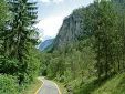
From Pergine to Levico, then ascent to Menador, then up to Passo Vezzena and from there another pass that leads to Luserna. From Luserna, take the flat road to Monterovere and continue to Lavarone and Carbonare. From Carbonare, take the road to Folgaria and upon arriving at Passo Sommo, turn left towards Tonezza and you arrive at Altopiano dei Fiorentini. From here, return to Carbonare via the same road and turn left towards Passo della Fricca. Then descend towards Pian dei Pradi, and just after turn right towards Campregheri and descend a narrow road through the woods down to Calceranica. From here, take the bike path and then return to Pergine via local roads.
- -:--
- Duration
- 99.5 km
- Distance
- 1,766 m
- Ascent
- 1,766 m
- Descent
- ---
- Avg. speed
- ---
- Max. altitude
Route quality
Waytypes & surfaces along the route
Waytypes
Quiet road
12.9 km
(13 %)
Road
11.9 km
(12 %)
Surfaces
Paved
79.6 km
(80 %)
Asphalt
79.6 km
(80 %)
Undefined
19.9 km
(20 %)
Continue with Bikemap
Use, edit, or download this cycling route
You would like to ride Pergine - Menador - Luserna - Carbonare - Fiorentini Carbonare - Campregheri - Pergine or customize it for your own trip? Here is what you can do with this Bikemap route:
Free features
- Save this route as favorite or in collections
- Copy & plan your own version of this route
- Split it into stages to create a multi-day tour
- Sync your route with Garmin or Wahoo
Premium features
Free trial for 3 days, or one-time payment. More about Bikemap Premium.
- Navigate this route on iOS & Android
- Export a GPX / KML file of this route
- Create your custom printout (try it for free)
- Download this route for offline navigation
Discover more Premium features.
Get Bikemap PremiumFrom our community
Other popular routes starting in Pergine Valsugana
 Pergine - Menador - Luserna - Carbonare - Fiorentini Carbonare - Campregheri - Pergine
- Distance
- 99.5 km
- Ascent
- 1,766 m
- Descent
- 1,766 m
- Location
- Pergine Valsugana, Trentino-Alto Adige, Italy
 VS_ Pergine - Bassano del Grappa
- Distance
- 85.4 km
- Ascent
- 193 m
- Descent
- 552 m
- Location
- Pergine Valsugana, Trentino-Alto Adige, Italy
 v277 ciclabile Valsugana - PERGINE - BASSANO (pisteciclabili)
- Distance
- 82.1 km
- Ascent
- 147 m
- Descent
- 501 m
- Location
- Pergine Valsugana, Trentino-Alto Adige, Italy
 🚴♀️E*Bike🇮🇩 2.Tag Radweg Valsugana
- Distance
- 48.9 km
- Ascent
- 79 m
- Descent
- 312 m
- Location
- Pergine Valsugana, Trentino-Alto Adige, Italy
 Giro del castello e lago (via Tenna)
- Distance
- 25.4 km
- Ascent
- 255 m
- Descent
- 253 m
- Location
- Pergine Valsugana, Trentino-Alto Adige, Italy
 CALDONAZZO-MANGHEN-BEDOLLO
- Distance
- 108.8 km
- Ascent
- 2,025 m
- Descent
- 2,023 m
- Location
- Pergine Valsugana, Trentino-Alto Adige, Italy
 giro dei laghi 2
- Distance
- 23.4 km
- Ascent
- 520 m
- Descent
- 515 m
- Location
- Pergine Valsugana, Trentino-Alto Adige, Italy
 Giro dei laghi breve
- Distance
- 24.8 km
- Ascent
- 260 m
- Descent
- 260 m
- Location
- Pergine Valsugana, Trentino-Alto Adige, Italy
Open it in the app