

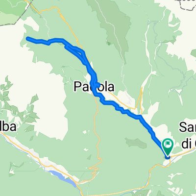
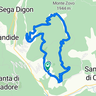
ANELLO DA COSTALISSOIO, MONTE ZOVO, COSTA, COSTALISSOIO - Santo Stefano di Cadore, San Nicolò di Comelico
A cycling route starting in Santo Stefano di Cadore, Veneto, Italy.
Overview
About this route
Monte Zovo is one of the viewpoints of Val Comelico, offering a 360° view of all the surrounding peaks.
- -:--
- Duration
- 16 km
- Distance
- 843 m
- Ascent
- 868 m
- Descent
- ---
- Avg. speed
- ---
- Max. altitude
Continue with Bikemap
Use, edit, or download this cycling route
You would like to ride ANELLO DA COSTALISSOIO, MONTE ZOVO, COSTA, COSTALISSOIO - Santo Stefano di Cadore, San Nicolò di Comelico or customize it for your own trip? Here is what you can do with this Bikemap route:
Free features
- Save this route as favorite or in collections
- Copy & plan your own version of this route
- Sync your route with Garmin or Wahoo
Premium features
Free trial for 3 days, or one-time payment. More about Bikemap Premium.
- Navigate this route on iOS & Android
- Export a GPX / KML file of this route
- Create your custom printout (try it for free)
- Download this route for offline navigation
Discover more Premium features.
Get Bikemap PremiumFrom our community
Other popular routes starting in Santo Stefano di Cadore
 Piazzale 11 Settembre 2001, Santo Stefano di Cadore a Piazzale 11 Settembre 2001, Santo Stefano di Cadore
- Distance
- 33 km
- Ascent
- 815 m
- Descent
- 811 m
- Location
- Santo Stefano di Cadore, Veneto, Italy
 ANELLO DA COSTALISSOIO, MONTE ZOVO, COSTA, COSTALISSOIO - Santo Stefano di Cadore, San Nicolò di Comelico
- Distance
- 16 km
- Ascent
- 843 m
- Descent
- 868 m
- Location
- Santo Stefano di Cadore, Veneto, Italy
 16/2018 - Santo Stefano Cadore, Costalta
- Distance
- 27.8 km
- Ascent
- 1,025 m
- Descent
- 1,024 m
- Location
- Santo Stefano di Cadore, Veneto, Italy
 St. Stefano-Innichen
- Distance
- 32.9 km
- Ascent
- 947 m
- Descent
- 680 m
- Location
- Santo Stefano di Cadore, Veneto, Italy
 Alpy 2014 | z Prata na Plockenpass | 04 - Cima Sappada / Zoncolan / Plockenpass
- Distance
- 82.2 km
- Ascent
- 2,480 m
- Descent
- 2,023 m
- Location
- Santo Stefano di Cadore, Veneto, Italy
 Var. 3 - S.Stefano e dintorni
- Distance
- 31.8 km
- Ascent
- 783 m
- Descent
- 783 m
- Location
- Santo Stefano di Cadore, Veneto, Italy
 Santo Stefano - valvisdende
- Distance
- 11.8 km
- Ascent
- 452 m
- Descent
- 73 m
- Location
- Santo Stefano di Cadore, Veneto, Italy
 Comelico MTB
- Distance
- 56.6 km
- Ascent
- 1,446 m
- Descent
- 1,447 m
- Location
- Santo Stefano di Cadore, Veneto, Italy
Open it in the app