

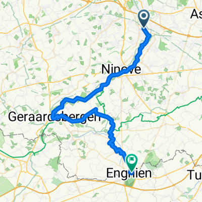
Dender - Asse
A cycling route starting in Denderleeuw, Flemish Region, Belgium.
Overview
About this route
- -:--
- Duration
- 10 km
- Distance
- 87 m
- Ascent
- 25 m
- Descent
- ---
- Avg. speed
- ---
- Max. altitude
Route quality
Waytypes & surfaces along the route
Waytypes
Quiet road
6.4 km
(64 %)
Track
1.4 km
(14 %)
Surfaces
Paved
3.1 km
(31 %)
Unpaved
1.5 km
(15 %)
Asphalt
3 km
(30 %)
Ground
1.5 km
(15 %)
Continue with Bikemap
Use, edit, or download this cycling route
You would like to ride Dender - Asse or customize it for your own trip? Here is what you can do with this Bikemap route:
Free features
- Save this route as favorite or in collections
- Copy & plan your own version of this route
- Sync your route with Garmin or Wahoo
Premium features
Free trial for 3 days, or one-time payment. More about Bikemap Premium.
- Navigate this route on iOS & Android
- Export a GPX / KML file of this route
- Create your custom printout (try it for free)
- Download this route for offline navigation
Discover more Premium features.
Get Bikemap PremiumFrom our community
Other popular routes starting in Denderleeuw
 Iddergem 16 km
- Distance
- 16.6 km
- Ascent
- 52 m
- Descent
- 53 m
- Location
- Denderleeuw, Flemish Region, Belgium
 Affligem-GroenKort-24km-340hm
- Distance
- 23.7 km
- Ascent
- 180 m
- Descent
- 180 m
- Location
- Denderleeuw, Flemish Region, Belgium
 Dender - Asse
- Distance
- 10 km
- Ascent
- 87 m
- Descent
- 25 m
- Location
- Denderleeuw, Flemish Region, Belgium
 Pajotse Panorama route - from Denderleeuw tain
- Distance
- 45.7 km
- Ascent
- 413 m
- Descent
- 416 m
- Location
- Denderleeuw, Flemish Region, Belgium
 zone de silence 1
- Distance
- 48.1 km
- Ascent
- 276 m
- Descent
- 233 m
- Location
- Denderleeuw, Flemish Region, Belgium
 Slotrit CC
- Distance
- 71 km
- Ascent
- 407 m
- Descent
- 438 m
- Location
- Denderleeuw, Flemish Region, Belgium
 Denderleeuw-Blauw-19km-160hm
- Distance
- 18.9 km
- Ascent
- 98 m
- Descent
- 96 m
- Location
- Denderleeuw, Flemish Region, Belgium
 Affligem-GroenKort-24km-340hm
- Distance
- 23.8 km
- Ascent
- 237 m
- Descent
- 239 m
- Location
- Denderleeuw, Flemish Region, Belgium
Open it in the app