Aurich-Ogenbargen nach Jever
- 25.4 km
- 16 m
- 12 m
- Blomberg, Lower Saxony, Germany
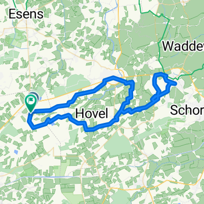
A cycling route starting in Blomberg, Lower Saxony, Germany.
Overview
The Holtriem region is a true paradise for cycling tourists. Cycle paths run alongside almost all major roads and the Holtriem circular trail, a route away from the main roads, invites riders to explore the area by bike. The Holtriem-Wander-Weg is roughly 48 km long and leads through the scenic landscape of Holtriem, linking existing country roads into an attractive circular cycling itinerary. The idea for this trail originated in 1987. Year after year, sections of the trail were completed until the final connection between Nenndorf and Westerholt was established in 1991 with the creation of the 'Lang Pad'. The Holtriem-Wander-Weg is well signposted and is gradually being furnished with shelters and information boards. Both guests and locals enjoy the route, especially since it can be left at any village, making it easy for families with children to explore partial sections according to their abilities. Even longer-distance routes like the 'Friesischer Heerweg' or 'Mit Rad up't Möhlenpad' incorporate stretches of the Holtriem-Wander-Weg. Along both sides of the trail, cyclists are greeted by interesting sights and local curiosities. For example, the route crosses the 7 degrees 30 minutes boundary meridian twice (in Utarp and Neuschoo). This meridian, east of Greenwich, marks the theoretical border between Western European and Central European Time. The time difference between the two is one hour. For daily convenience, there is no longer a requirement to reset your watch when crossing this line, but signs highlight these borders and explain the purpose of the boundary meridian. Discover these remarkable boundaries for yourself on a ride along the Holtriem-Wander-Weg.
created this 5 years ago
Route quality
Quiet road
16.7 km
(43 %)
Track
12.8 km
(33 %)
Paved
22.9 km
(59 %)
Asphalt
11.7 km
(30 %)
Paved (undefined)
11.3 km
(29 %)
Undefined
15.9 km
(41 %)
Route highlights

KBV "Freesenmoot" Nenndorf e.V. von 1919 Ostfriesischer Kloot und Boßelverein

Gaststätte "Holtriemer Hof"

Die Mühle Nenndorf wurde 1850 gebaut. Der Galerie-Holländer brannte 1872 aus und wurde zweistöckig wieder aufgebaut. Die mit Wind voll funktionsfähige Mühle hat zwei Mahlgänge und einen Peldegang.

Herzlich willkommen bei HM Fahrräder Ihrem neuen Fahrrad-Fachgeschäft in Westerholt, Ostfriesland. Seit Mai sind wir in der Nordener Straße 13 (ehemals Möbel Backer) für Sie da! Auf über 200m² bieten wir Ihnen eine große Auswahl an E-Bikes, Fahrrädern, Kinderrädern und Zubehör. Bei uns ist ihr Fahrrad in besten Händen. Mit über 20 Jahren Erfahrung führen wir Servicearbeiten rund ums Fahrrad gewissenhaft aus. Mit unseren starken Partnern Jobrad und Wertgarantie ist die Basis für attraktive Leasing- und Absicherungsmöglichkeiten gegeben. Für unsere Nordseeurlauber bieten wir optisch ansprechende und leistungstechnisch überzeugende Victoria®-Fahrräder und E-Bikes zum Preis von 7,00€ bzw. 20,00€, sowie Kinderräder und praktisches Zubehör ab 5€ pro Tag an. Weitere Details finden Sie auf unserer Verleih-Seite. Sowohl unsere Neu- als auch unsere Verleihräder liefern wir gerne direkt zu Ihnen nach Hause. Im Umkreis von 15km sogar kostenlos.

Fahrradservice Janssen Blomberg

Gaststätte "Dörpkroog"
Continue with Bikemap
You would like to ride Holtriemer-Wanderweg or customize it for your own trip? Here is what you can do with this Bikemap route:
Free trial for 3 days, or one-time payment. More about Bikemap Premium.
Discover more Premium features.
Get Bikemap PremiumFrom our community
Open it in the app