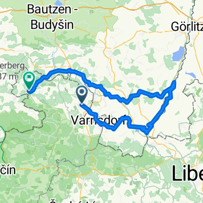
Okolo Dymniku
A cycling route starting in Rumburk, Ústecký kraj, Czechia.
Overview
About this route
Sunday outing with the children on secondary roads and country tracks
- -:--
- Duration
- 15.9 km
- Distance
- 144 m
- Ascent
- 151 m
- Descent
- ---
- Avg. speed
- ---
- Max. altitude
Route quality
Waytypes & surfaces along the route
Waytypes
Quiet road
9.2 km
(58 %)
Track
5.1 km
(32 %)
Surfaces
Paved
7.3 km
(46 %)
Unpaved
1.9 km
(12 %)
Asphalt
6.7 km
(42 %)
Ground
1.4 km
(9 %)
Continue with Bikemap
Use, edit, or download this cycling route
You would like to ride Okolo Dymniku or customize it for your own trip? Here is what you can do with this Bikemap route:
Free features
- Save this route as favorite or in collections
- Copy & plan your own version of this route
- Sync your route with Garmin or Wahoo
Premium features
Free trial for 3 days, or one-time payment. More about Bikemap Premium.
- Navigate this route on iOS & Android
- Export a GPX / KML file of this route
- Create your custom printout (try it for free)
- Download this route for offline navigation
Discover more Premium features.
Get Bikemap PremiumFrom our community
Other popular routes starting in Rumburk
Tour de Zeleńák- Distance
- 53.5 km
- Ascent
- 623 m
- Descent
- 622 m
- Location
- Rumburk, Ústecký kraj, Czechia
Rumburk-Krásná Lípa-Chřibská-Česká Kamenice-Mlýny-Kytlice-Dolní Podluží-Varnsdorf-Seifhennersdorf-Rumburk- Distance
- 61.4 km
- Ascent
- 662 m
- Descent
- 662 m
- Location
- Rumburk, Ústecký kraj, Czechia
Do Neusalza-Spremberk na koupaliště- Distance
- 33.9 km
- Ascent
- 294 m
- Descent
- 305 m
- Location
- Rumburk, Ústecký kraj, Czechia
Hainewalde- Distance
- 45.3 km
- Ascent
- 933 m
- Descent
- 930 m
- Location
- Rumburk, Ústecký kraj, Czechia
Kristýna- Distance
- 75 km
- Ascent
- 3,273 m
- Descent
- 3,267 m
- Location
- Rumburk, Ústecký kraj, Czechia
Mandava-Nisa-Spréva- Distance
- 116.7 km
- Ascent
- 594 m
- Descent
- 637 m
- Location
- Rumburk, Ústecký kraj, Czechia
Lipová-Sohland-bloudění u Fukova-Spremberg-Jiříkov-Rbk- Distance
- 49.5 km
- Ascent
- 954 m
- Descent
- 950 m
- Location
- Rumburk, Ústecký kraj, Czechia
Pod Jitrovníkem a Valdecká stezka- Distance
- 28.3 km
- Ascent
- 257 m
- Descent
- 257 m
- Location
- Rumburk, Ústecký kraj, Czechia
Open it in the app

