
Kocher-Jagst Radtour 2008
A cycling route starting in Langenburg, Baden-Wurttemberg, Germany.
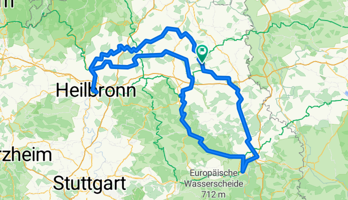
Overview
About this route
<p>Kocher-Jagst cycling tour</p>
<p>A 6 - 7 day tour</p>
Translated, show original (German)- -:--
- Duration
- 340.2 km
- Distance
- 1,603 m
- Ascent
- 1,803 m
- Descent
- ---
- Avg. speed
- 515 m
- Max. altitude
Route quality
Waytypes & surfaces along the route
Waytypes
Track
146.3 km
(43 %)
Quiet road
71.4 km
(21 %)
Surfaces
Paved
306.2 km
(90 %)
Unpaved
6.8 km
(2 %)
Asphalt
272.2 km
(80 %)
Paved (undefined)
30.6 km
(9 %)
Continue with Bikemap
Use, edit, or download this cycling route
You would like to ride Kocher-Jagst Radtour 2008 or customize it for your own trip? Here is what you can do with this Bikemap route:
Free features
- Save this route as favorite or in collections
- Copy & plan your own version of this route
- Split it into stages to create a multi-day tour
- Sync your route with Garmin or Wahoo
Premium features
Free trial for 3 days, or one-time payment. More about Bikemap Premium.
- Navigate this route on iOS & Android
- Export a GPX / KML file of this route
- Create your custom printout (try it for free)
- Download this route for offline navigation
Discover more Premium features.
Get Bikemap PremiumFrom our community
Other popular routes starting in Langenburg
 Langenburg bis Jagsthausen Kocher-Jagst
- Distance
- 89 km
- Ascent
- 582 m
- Descent
- 579 m
- Location
- Langenburg, Baden-Wurttemberg, Germany
 Tierberg-Kocherstetten-Steinkirchen-Tierberg
- Distance
- 26.5 km
- Ascent
- 480 m
- Descent
- 481 m
- Location
- Langenburg, Baden-Wurttemberg, Germany
 Rundtour-2014-Tag-5
- Distance
- 82.2 km
- Ascent
- 439 m
- Descent
- 307 m
- Location
- Langenburg, Baden-Wurttemberg, Germany
 Kocher-Jagst-Abschnitt-60Km
- Distance
- 60 km
- Ascent
- 576 m
- Descent
- 577 m
- Location
- Langenburg, Baden-Wurttemberg, Germany
 2010-Tag 13(Teil1): Langenburg-Blaufelden
- Distance
- 11.1 km
- Ascent
- 130 m
- Descent
- 85 m
- Location
- Langenburg, Baden-Wurttemberg, Germany
 Kocher - Jagst
- Distance
- 26.6 km
- Ascent
- 276 m
- Descent
- 430 m
- Location
- Langenburg, Baden-Wurttemberg, Germany
 8 Freunde 2017 , 2. Tag
- Distance
- 58.9 km
- Ascent
- 365 m
- Descent
- 377 m
- Location
- Langenburg, Baden-Wurttemberg, Germany
 Blaufeldener Straße 14, Gerabronn nach Blaufeldener Straße 10, Gerabronn
- Distance
- 15.1 km
- Ascent
- 151 m
- Descent
- 148 m
- Location
- Langenburg, Baden-Wurttemberg, Germany
Open it in the app