

vejen
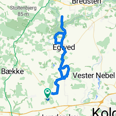
A cycling route starting in Lunderskov, Region South Denmark, Denmark.
Overview
About this route
from Lundersov northwards and over Vejen to Skanderup
- -:--
- Duration
- 49.1 km
- Distance
- 110 m
- Ascent
- 112 m
- Descent
- ---
- Avg. speed
- ---
- Max. altitude

Route quality
Waytypes & surfaces along the route
Waytypes
Quiet road
23.5 km
(48 %)
Road
16.7 km
(34 %)
Surfaces
Paved
38.8 km
(79 %)
Unpaved
6.9 km
(14 %)
Asphalt
36.8 km
(75 %)
Gravel
5.9 km
(12 %)
Continue with Bikemap
Use, edit, or download this cycling route
You would like to ride vejen or customize it for your own trip? Here is what you can do with this Bikemap route:
Free features
- Save this route as favorite or in collections
- Copy & plan your own version of this route
- Sync your route with Garmin or Wahoo
Premium features
Free trial for 3 days, or one-time payment. More about Bikemap Premium.
- Navigate this route on iOS & Android
- Export a GPX / KML file of this route
- Create your custom printout (try it for free)
- Download this route for offline navigation
Discover more Premium features.
Get Bikemap PremiumFrom our community
Other popular routes starting in Lunderskov
 Lunderskov via Knagmølle Rødding
- Distance
- 36.8 km
- Ascent
- 100 m
- Descent
- 103 m
- Location
- Lunderskov, Region South Denmark, Denmark
 Egtvedpigen Tyndskid
- Distance
- 52.6 km
- Ascent
- 386 m
- Descent
- 386 m
- Location
- Lunderskov, Region South Denmark, Denmark
 Tulipantour
- Distance
- 108.9 km
- Ascent
- 287 m
- Descent
- 286 m
- Location
- Lunderskov, Region South Denmark, Denmark
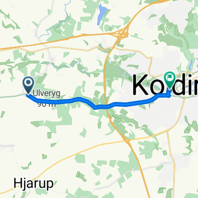 Ulveryg to Kolding
- Distance
- 7.7 km
- Ascent
- 48 m
- Descent
- 123 m
- Location
- Lunderskov, Region South Denmark, Denmark
 rundt om Vejen
- Distance
- 50.8 km
- Ascent
- 121 m
- Descent
- 121 m
- Location
- Lunderskov, Region South Denmark, Denmark
 Møllegade 23, Lunderskov to Møllegade 23P, Lunderskov
- Distance
- 38.4 km
- Ascent
- 168 m
- Descent
- 169 m
- Location
- Lunderskov, Region South Denmark, Denmark
 Lyngbakkevej 25, Vejen to Lyngbakkevej 25, Vejen
- Distance
- 15.3 km
- Ascent
- 51 m
- Descent
- 54 m
- Location
- Lunderskov, Region South Denmark, Denmark
 Lunderskovvej, Lunderskov to Karolinegade 2T, Kolding
- Distance
- 11.7 km
- Ascent
- 90 m
- Descent
- 126 m
- Location
- Lunderskov, Region South Denmark, Denmark
Open it in the app