

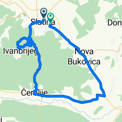
Slanac-Centar
A cycling route starting in Slatina, Virovitica-Podravina County, Croatia.
Overview
About this route
- -:--
- Duration
- 11.3 km
- Distance
- 58 m
- Ascent
- 52 m
- Descent
- ---
- Avg. speed
- ---
- Max. altitude

Route photos


Route quality
Waytypes & surfaces along the route
Waytypes
Track
1.6 km
(14 %)
Undefined
9.7 km
(86 %)
Surfaces
Paved
9.7 km
(86 %)
Asphalt
9.7 km
(86 %)
Undefined
1.6 km
(14 %)
Continue with Bikemap
Use, edit, or download this cycling route
You would like to ride Slanac-Centar or customize it for your own trip? Here is what you can do with this Bikemap route:
Free features
- Save this route as favorite or in collections
- Copy & plan your own version of this route
- Sync your route with Garmin or Wahoo
Premium features
Free trial for 3 days, or one-time payment. More about Bikemap Premium.
- Navigate this route on iOS & Android
- Export a GPX / KML file of this route
- Create your custom printout (try it for free)
- Download this route for offline navigation
Discover more Premium features.
Get Bikemap PremiumFrom our community
Other popular routes starting in Slatina
 Slatina-NP Jankovac-Velika-Zvecevo-Vocin-Slatina
- Distance
- 122.3 km
- Ascent
- 1,296 m
- Descent
- 1,300 m
- Location
- Slatina, Virovitica-Podravina County, Croatia
 b.s. uz rijeku Dravu
- Distance
- 21.6 km
- Ascent
- 22 m
- Descent
- 20 m
- Location
- Slatina, Virovitica-Podravina County, Croatia
 Slatina and surroundings
- Distance
- 42.5 km
- Ascent
- 292 m
- Descent
- 295 m
- Location
- Slatina, Virovitica-Podravina County, Croatia
 Route in Slatina
- Distance
- 59.1 km
- Ascent
- 387 m
- Descent
- 389 m
- Location
- Slatina, Virovitica-Podravina County, Croatia
 Papuk
Papuk- Distance
- 216.7 km
- Ascent
- 1,925 m
- Descent
- 1,926 m
- Location
- Slatina, Virovitica-Podravina County, Croatia
 Đir po Papuku
- Distance
- 63.2 km
- Ascent
- 701 m
- Descent
- 699 m
- Location
- Slatina, Virovitica-Podravina County, Croatia
 cadavica to mohacs
- Distance
- 95.4 km
- Ascent
- 298 m
- Descent
- 311 m
- Location
- Slatina, Virovitica-Podravina County, Croatia
 Slatina-D.Miholjac-Harkany-Barcs-Suhopolje-Slatina
- Distance
- 182 km
- Ascent
- 71 m
- Descent
- 73 m
- Location
- Slatina, Virovitica-Podravina County, Croatia
Open it in the app