
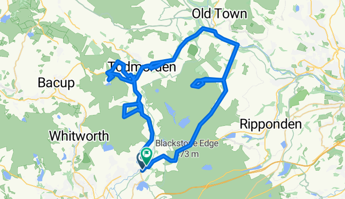
Littleborough/Hebden Bridge
A cycling route starting in Littleborough, England, United Kingdom.
Overview
About this route
- -:--
- Duration
- 55.3 km
- Distance
- 903 m
- Ascent
- 909 m
- Descent
- ---
- Avg. speed
- ---
- Max. altitude

Route highlights
Points of interest along the route
Point of interest after 23.5 km
Gaddings Dam
Continue with Bikemap
Use, edit, or download this cycling route
You would like to ride Littleborough/Hebden Bridge or customize it for your own trip? Here is what you can do with this Bikemap route:
Free features
- Save this route as favorite or in collections
- Copy & plan your own version of this route
- Sync your route with Garmin or Wahoo
Premium features
Free trial for 3 days, or one-time payment. More about Bikemap Premium.
- Navigate this route on iOS & Android
- Export a GPX / KML file of this route
- Create your custom printout (try it for free)
- Download this route for offline navigation
Discover more Premium features.
Get Bikemap PremiumFrom our community
Other popular routes starting in Littleborough
 DAM circle ride
- Distance
- 31.5 km
- Ascent
- 400 m
- Descent
- 478 m
- Location
- Littleborough, England, United Kingdom
 home route 1
- Distance
- 34.5 km
- Ascent
- 389 m
- Descent
- 393 m
- Location
- Littleborough, England, United Kingdom
 Hollingsworth lake
- Distance
- 4.2 km
- Ascent
- 50 m
- Descent
- 55 m
- Location
- Littleborough, England, United Kingdom
 Hollingworth loop
- Distance
- 11.8 km
- Ascent
- 336 m
- Descent
- 337 m
- Location
- Littleborough, England, United Kingdom
 Calderdale PBW denshaw mobsy
- Distance
- 13.9 km
- Ascent
- 394 m
- Descent
- 396 m
- Location
- Littleborough, England, United Kingdom
 20, Summit, Littleborough to Chew Road, Greenfield, Oldham
- Distance
- 23.6 km
- Ascent
- 396 m
- Descent
- 353 m
- Location
- Littleborough, England, United Kingdom
 12, Summit, Littleborough to 720 Halifax Road, Rochdale
- Distance
- 23.9 km
- Ascent
- 545 m
- Descent
- 565 m
- Location
- Littleborough, England, United Kingdom
 Littleborough/Hebden Bridge
- Distance
- 55.3 km
- Ascent
- 903 m
- Descent
- 909 m
- Location
- Littleborough, England, United Kingdom
Open it in the app