

05_Schonach-Breitnau
A cycling route starting in Schonach im Schwarzwald, Baden-Wurttemberg, Germany.
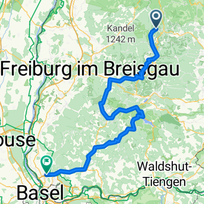
Overview
About this route
For sporty cyclists, the roughly 440-kilometer-long ‚Bike-X-ing Schwarzwald‘ from Pforzheim to Bad Säckingen has become a cult favorite. The marked route runs through the Black Forest to Bad Säckingen at the Swiss border. It can be divided into various daily stages. In total, there are over 16,000 meters of elevation gain to conquer, with average-trained mountain bikers expected to complete the entire route in seven to eight days. Note: The signage for the Bike-Crossing Schwarzwald may have gaps. We recommend digital navigation with a GPS device or the free SchwarzwaldApp.
- -:--
- Duration
- 62.7 km
- Distance
- 2,190 m
- Ascent
- 2,043 m
- Descent
- ---
- Avg. speed
- ---
- Max. altitude
Route quality
Waytypes & surfaces along the route
Waytypes
Track
28.2 km
(45 %)
Quiet road
21.9 km
(35 %)
Surfaces
Paved
29.5 km
(47 %)
Unpaved
27.6 km
(44 %)
Asphalt
27 km
(43 %)
Gravel
21.9 km
(35 %)
Continue with Bikemap
Use, edit, or download this cycling route
You would like to ride 05_Schonach-Breitnau or customize it for your own trip? Here is what you can do with this Bikemap route:
Free features
- Save this route as favorite or in collections
- Copy & plan your own version of this route
- Sync your route with Garmin or Wahoo
Premium features
Free trial for 3 days, or one-time payment. More about Bikemap Premium.
- Navigate this route on iOS & Android
- Export a GPX / KML file of this route
- Create your custom printout (try it for free)
- Download this route for offline navigation
Discover more Premium features.
Get Bikemap PremiumFrom our community
Other popular routes starting in Schonach im Schwarzwald
 Rund um Schönwald (31km)
- Distance
- 31.5 km
- Ascent
- 705 m
- Descent
- 705 m
- Location
- Schonach im Schwarzwald, Baden-Wurttemberg, Germany
 Sonnwendfahrt 2013 über Donautal
- Distance
- 337.7 km
- Ascent
- 629 m
- Descent
- 961 m
- Location
- Schonach im Schwarzwald, Baden-Wurttemberg, Germany
 Schonach - Binzen
- Distance
- 153.7 km
- Ascent
- 2,226 m
- Descent
- 2,812 m
- Location
- Schonach im Schwarzwald, Baden-Wurttemberg, Germany
 Schonach im Schwarzwald
- Distance
- 6.8 km
- Ascent
- 237 m
- Descent
- 228 m
- Location
- Schonach im Schwarzwald, Baden-Wurttemberg, Germany
 Sonnwendfahrt 2016 Schonach-Zugspitze
- Distance
- 315.4 km
- Ascent
- 1,234 m
- Descent
- 1,129 m
- Location
- Schonach im Schwarzwald, Baden-Wurttemberg, Germany
 05_Schonach-Breitnau
- Distance
- 62.7 km
- Ascent
- 2,190 m
- Descent
- 2,043 m
- Location
- Schonach im Schwarzwald, Baden-Wurttemberg, Germany
 Schonach im Schwarzwald rund Kurs mit 2 Trails
- Distance
- 12 km
- Ascent
- 796 m
- Descent
- 802 m
- Location
- Schonach im Schwarzwald, Baden-Wurttemberg, Germany
 Schonach über Westweg nach Zell a. H.
- Distance
- 35.8 km
- Ascent
- 371 m
- Descent
- 1,115 m
- Location
- Schonach im Schwarzwald, Baden-Wurttemberg, Germany
Open it in the app