

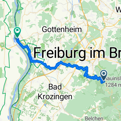
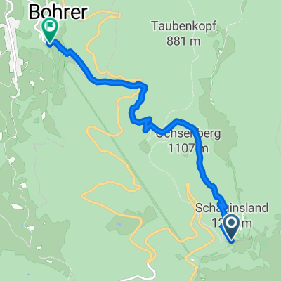
13 Schauinsland - Eduardshöhe - Horben
A cycling route starting in Horben, Baden-Wurttemberg, Germany.
Overview
About this route
Bergstation Schauinsland Bahn - Talstation Horben
- -:--
- Duration
- 12.4 km
- Distance
- 150 m
- Ascent
- 874 m
- Descent
- ---
- Avg. speed
- ---
- Max. altitude

Route quality
Waytypes & surfaces along the route
Waytypes
Track
4.5 km
(36 %)
Path
2.7 km
(22 %)
Surfaces
Paved
4.7 km
(38 %)
Unpaved
6.7 km
(54 %)
Asphalt
4.2 km
(34 %)
Ground
3.4 km
(27 %)
Continue with Bikemap
Use, edit, or download this cycling route
You would like to ride 13 Schauinsland - Eduardshöhe - Horben or customize it for your own trip? Here is what you can do with this Bikemap route:
Free features
- Save this route as favorite or in collections
- Copy & plan your own version of this route
- Sync your route with Garmin or Wahoo
Premium features
Free trial for 3 days, or one-time payment. More about Bikemap Premium.
- Navigate this route on iOS & Android
- Export a GPX / KML file of this route
- Create your custom printout (try it for free)
- Download this route for offline navigation
Discover more Premium features.
Get Bikemap PremiumFrom our community
Other popular routes starting in Horben
 38 Horben - Tiengen - Breisach
- Distance
- 37.9 km
- Ascent
- 749 m
- Descent
- 990 m
- Location
- Horben, Baden-Wurttemberg, Germany
 BUND Schauitag
- Distance
- 87.6 km
- Ascent
- 1,375 m
- Descent
- 1,578 m
- Location
- Horben, Baden-Wurttemberg, Germany
 Schauinsland - Trail
- Distance
- 16.4 km
- Ascent
- 139 m
- Descent
- 1,119 m
- Location
- Horben, Baden-Wurttemberg, Germany
 schauinsland
- Distance
- 11.7 km
- Ascent
- 780 m
- Descent
- 28 m
- Location
- Horben, Baden-Wurttemberg, Germany
 Schauinsland-Freiburg-Notschrei-Todtnau-Utzenfeld-Schauinsland-Halde
- Distance
- 81.6 km
- Ascent
- 1,709 m
- Descent
- 2,062 m
- Location
- Horben, Baden-Wurttemberg, Germany
 Schauinsland- Downhill- I
- Distance
- 5.4 km
- Ascent
- 87 m
- Descent
- 887 m
- Location
- Horben, Baden-Wurttemberg, Germany
 Schauinsland-Belchen Tour
- Distance
- 63 km
- Ascent
- 1,507 m
- Descent
- 1,510 m
- Location
- Horben, Baden-Wurttemberg, Germany
 13 Schauinsland - Eduardshöhe - Horben
- Distance
- 12.4 km
- Ascent
- 150 m
- Descent
- 874 m
- Location
- Horben, Baden-Wurttemberg, Germany
Open it in the app