

Las grutas - El Fuerte
A cycling route starting in San Antonio Oeste, Río Negro Province, Argentina.
Overview
About this route
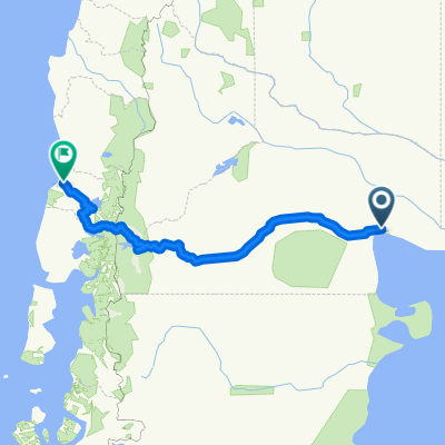
Coastal route of the San Matias Gulf, path through part of the trail, route by the farmers and merchants of the area, the Fort is a plain where it is said the Calis is. The path is sandy, crossed by ravines. To take into account:
- Water
- Food
- High temperatures in summer
- Little to no shelter
- No traffic
- Caution with quads
- Sunscreen
- -:--
- Duration
- 37.1 km
- Distance
- 146 m
- Ascent
- 47 m
- Descent
- ---
- Avg. speed
- ---
- Max. altitude

Continue with Bikemap
Use, edit, or download this cycling route
You would like to ride Las grutas - El Fuerte or customize it for your own trip? Here is what you can do with this Bikemap route:
Free features
- Save this route as favorite or in collections
- Copy & plan your own version of this route
- Sync your route with Garmin or Wahoo
Premium features
Free trial for 3 days, or one-time payment. More about Bikemap Premium.
- Navigate this route on iOS & Android
- Export a GPX / KML file of this route
- Create your custom printout (try it for free)
- Download this route for offline navigation
Discover more Premium features.
Get Bikemap PremiumFrom our community
Other popular routes starting in San Antonio Oeste
 Vuelta a la Argentina. Parte 10
- Distance
- 189.9 km
- Ascent
- 196 m
- Descent
- 218 m
- Location
- San Antonio Oeste, Río Negro Province, Argentina
 FUERTE ARGENTINO--LAS GRUTAS,,
- Distance
- 35.8 km
- Ascent
- 36 m
- Descent
- 39 m
- Location
- San Antonio Oeste, Río Negro Province, Argentina
 Etap XVII RN23 i na południe
- Distance
- 2,268.6 km
- Ascent
- 14,576 m
- Descent
- 14,207 m
- Location
- San Antonio Oeste, Río Negro Province, Argentina
 Primer viaje Patagonia 1994, primera parte
- Distance
- 1,980.4 km
- Ascent
- 1,930 m
- Descent
- 1,934 m
- Location
- San Antonio Oeste, Río Negro Province, Argentina
 San Antonio del Oeste - Valdés
- Distance
- 465.7 km
- Ascent
- 544 m
- Descent
- 538 m
- Location
- San Antonio Oeste, Río Negro Province, Argentina
 Las grutas
- Distance
- 37.4 km
- Ascent
- 233 m
- Descent
- 233 m
- Location
- San Antonio Oeste, Río Negro Province, Argentina
 Etap XVIII Las Grutas i na północ
- Distance
- 4,025.7 km
- Ascent
- 17,295 m
- Descent
- 17,218 m
- Location
- San Antonio Oeste, Río Negro Province, Argentina
 San Antonio Oeste to Valdivia with stops
- Distance
- 1,031.4 km
- Ascent
- 2,115 m
- Descent
- 2,114 m
- Location
- San Antonio Oeste, Río Negro Province, Argentina
Open it in the app