

Trans Bayerwald Nord Etappe 3
A cycling route starting in Philippsreut, Bavaria, Germany.
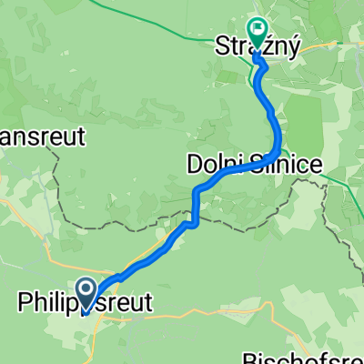
Overview
About this route
These GPS data are the property of the geo-coaching project and are intended solely for private use. Commercial use is not permitted without authorization.
- 9 h 27 min
- Duration
- 73 km
- Distance
- 1,863 m
- Ascent
- 2,149 m
- Descent
- 7.7 km/h
- Avg. speed
- ---
- Max. altitude
Route quality
Waytypes & surfaces along the route
Waytypes
Track
49.7 km
(68 %)
Quiet road
11.7 km
(16 %)
Surfaces
Paved
19 km
(26 %)
Unpaved
42.4 km
(58 %)
Gravel
30.7 km
(42 %)
Asphalt
17.5 km
(24 %)
Continue with Bikemap
Use, edit, or download this cycling route
You would like to ride Trans Bayerwald Nord Etappe 3 or customize it for your own trip? Here is what you can do with this Bikemap route:
Free features
- Save this route as favorite or in collections
- Copy & plan your own version of this route
- Sync your route with Garmin or Wahoo
Premium features
Free trial for 3 days, or one-time payment. More about Bikemap Premium.
- Navigate this route on iOS & Android
- Export a GPX / KML file of this route
- Create your custom printout (try it for free)
- Download this route for offline navigation
Discover more Premium features.
Get Bikemap PremiumFrom our community
Other popular routes starting in Philippsreut
 FDB - Budweis Etappe 3
- Distance
- 135.8 km
- Ascent
- 629 m
- Descent
- 1,235 m
- Location
- Philippsreut, Bavaria, Germany
 Trans Bayerwald Nord Etappe 3
- Distance
- 73 km
- Ascent
- 1,863 m
- Descent
- 2,149 m
- Location
- Philippsreut, Bavaria, Germany
 D20-Philippreuth-Ameisseee-Regenburg460
- Distance
- 494.9 km
- Ascent
- 917 m
- Descent
- 1,532 m
- Location
- Philippsreut, Bavaria, Germany
 Hauptstraße 12, Philippsreut nach Schlägler Hauptstraße 7
- Distance
- 45.1 km
- Ascent
- 772 m
- Descent
- 1,201 m
- Location
- Philippsreut, Bavaria, Germany
 Hauptstraße 17, Philippsreut nach Strážný
- Distance
- 7.8 km
- Ascent
- 194 m
- Descent
- 340 m
- Location
- Philippsreut, Bavaria, Germany
 FDB Budweis Etappe 3A
- Distance
- 134.6 km
- Ascent
- 467 m
- Descent
- 1,073 m
- Location
- Philippsreut, Bavaria, Germany
 Hauptstraße 3, Haidmühle nach 163, Lipno nad Vltavou
- Distance
- 58 km
- Ascent
- 603 m
- Descent
- 848 m
- Location
- Philippsreut, Bavaria, Germany
 Unnamed Road, Annathaler Wald nach Am Goldenen Steig 14, Mauth
- Distance
- 8.2 km
- Ascent
- 146 m
- Descent
- 326 m
- Location
- Philippsreut, Bavaria, Germany
Open it in the app