

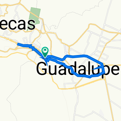
De Carretera Guadalupe-San Ramón 96 a Constitución de 1917 3, Guadalupe
A cycling route starting in Guadalupe, Zacatecas, Mexico.
Overview
About this route
- 3 h 36 min
- Duration
- 40.3 km
- Distance
- 344 m
- Ascent
- 345 m
- Descent
- 11.2 km/h
- Avg. speed
- ---
- Max. altitude

Continue with Bikemap
Use, edit, or download this cycling route
You would like to ride De Carretera Guadalupe-San Ramón 96 a Constitución de 1917 3, Guadalupe or customize it for your own trip? Here is what you can do with this Bikemap route:
Free features
- Save this route as favorite or in collections
- Copy & plan your own version of this route
- Sync your route with Garmin or Wahoo
Premium features
Free trial for 3 days, or one-time payment. More about Bikemap Premium.
- Navigate this route on iOS & Android
- Export a GPX / KML file of this route
- Create your custom printout (try it for free)
- Download this route for offline navigation
Discover more Premium features.
Get Bikemap PremiumFrom our community
Other popular routes starting in Guadalupe
 De Miguel Hidalgo, San Ramón a Miguel Hidalgo, San Ramón
- Distance
- 3.3 km
- Ascent
- 21 m
- Descent
- 20 m
- Location
- Guadalupe, Zacatecas, Mexico
 De Virreyes 13, Guadalupe a Zacatecas 175, Zoquite
- Distance
- 9.4 km
- Ascent
- 2 m
- Descent
- 20 m
- Location
- Guadalupe, Zacatecas, Mexico
 De Agapantos 133, Guadalupe a Agapantos 112, Guadalupe
- Distance
- 6 km
- Ascent
- 165 m
- Descent
- 155 m
- Location
- Guadalupe, Zacatecas, Mexico
 Ruta desde Calle A Sauceda de la Borda 4–14, Guadalupe
- Distance
- 8.5 km
- Ascent
- 320 m
- Descent
- 65 m
- Location
- Guadalupe, Zacatecas, Mexico
 De Agapantos 131, Guadalupe a Agapantos 116, Guadalupe
- Distance
- 6.7 km
- Ascent
- 188 m
- Descent
- 165 m
- Location
- Guadalupe, Zacatecas, Mexico
 De Carretera Guadalupe-San Ramón 96 a Constitución de 1917 3, Guadalupe
- Distance
- 40.3 km
- Ascent
- 344 m
- Descent
- 345 m
- Location
- Guadalupe, Zacatecas, Mexico
 De Agapantos 133, Guadalupe a Agapantos 106, Guadalupe
- Distance
- 16.8 km
- Ascent
- 208 m
- Descent
- 190 m
- Location
- Guadalupe, Zacatecas, Mexico
 De Agapantos 133, Guadalupe a Agapantos 131, Guadalupe
- Distance
- 4.8 km
- Ascent
- 138 m
- Descent
- 124 m
- Location
- Guadalupe, Zacatecas, Mexico
Open it in the app