

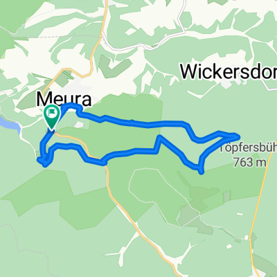
Rundtour Meurasteine und Assberg-Hasenleite
A cycling route starting in Meura, Thuringia, Germany.
Overview
About this route
- -:--
- Duration
- 10.7 km
- Distance
- 326 m
- Ascent
- 324 m
- Descent
- ---
- Avg. speed
- ---
- Max. altitude

Route quality
Waytypes & surfaces along the route
Waytypes
Track
8.5 km
(79 %)
Path
1.4 km
(13 %)
Surfaces
Paved
0.2 km
(2 %)
Unpaved
8.8 km
(82 %)
Gravel
4.2 km
(39 %)
Unpaved (undefined)
3.5 km
(33 %)
Continue with Bikemap
Use, edit, or download this cycling route
You would like to ride Rundtour Meurasteine und Assberg-Hasenleite or customize it for your own trip? Here is what you can do with this Bikemap route:
Free features
- Save this route as favorite or in collections
- Copy & plan your own version of this route
- Sync your route with Garmin or Wahoo
Premium features
Free trial for 3 days, or one-time payment. More about Bikemap Premium.
- Navigate this route on iOS & Android
- Export a GPX / KML file of this route
- Create your custom printout (try it for free)
- Download this route for offline navigation
Discover more Premium features.
Get Bikemap PremiumFrom our community
Other popular routes starting in Meura
 Meura-Leibis-Runde
- Distance
- 20.8 km
- Ascent
- 624 m
- Descent
- 637 m
- Location
- Meura, Thuringia, Germany
 Rund um die Talsperre Leibis
- Distance
- 21.6 km
- Ascent
- 911 m
- Descent
- 911 m
- Location
- Meura, Thuringia, Germany
 Meura- Lauscha Thüringer Wald
- Distance
- 55.3 km
- Ascent
- 941 m
- Descent
- 941 m
- Location
- Meura, Thuringia, Germany
 Schwarzatalrunde
- Distance
- 44.5 km
- Ascent
- 438 m
- Descent
- 416 m
- Location
- Meura, Thuringia, Germany
 Rundtour Meurasteine und Assberg-Hasenleite
- Distance
- 10.7 km
- Ascent
- 326 m
- Descent
- 324 m
- Location
- Meura, Thuringia, Germany
 Route Talsperre Leibis
- Distance
- 20.2 km
- Ascent
- 430 m
- Descent
- 190 m
- Location
- Meura, Thuringia, Germany
 Meura- Schwarzbachtal-Klosterradweg-Waldrandradweg-Meura
- Distance
- 64.1 km
- Ascent
- 677 m
- Descent
- 678 m
- Location
- Meura, Thuringia, Germany
 Route Saalfeld
- Distance
- 51.4 km
- Ascent
- 916 m
- Descent
- 1,247 m
- Location
- Meura, Thuringia, Germany
Open it in the app