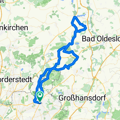
ost 75
A cycling route starting in Sasel, City state of Hamburg, Germany.
Overview
About this route
Road cycling route, 99% asphalt, only 100 m of solid gravel. Largely cleared of pointless navigation directions.
- -:--
- Duration
- 76.3 km
- Distance
- 154 m
- Ascent
- 156 m
- Descent
- ---
- Avg. speed
- ---
- Max. altitude
Route quality
Waytypes & surfaces along the route
Waytypes
Road
36.6 km
(48 %)
Quiet road
13.7 km
(18 %)
Surfaces
Paved
65.7 km
(86 %)
Unpaved
2.3 km
(3 %)
Asphalt
62.6 km
(82 %)
Paved (undefined)
3.1 km
(4 %)
Continue with Bikemap
Use, edit, or download this cycling route
You would like to ride ost 75 or customize it for your own trip? Here is what you can do with this Bikemap route:
Free features
- Save this route as favorite or in collections
- Copy & plan your own version of this route
- Sync your route with Garmin or Wahoo
Premium features
Free trial for 3 days, or one-time payment. More about Bikemap Premium.
- Navigate this route on iOS & Android
- Export a GPX / KML file of this route
- Create your custom printout (try it for free)
- Download this route for offline navigation
Discover more Premium features.
Get Bikemap PremiumFrom our community
Other popular routes starting in Sasel
Von Sasel rund um und durch den Brook- Distance
- 33.2 km
- Ascent
- 88 m
- Descent
- 91 m
- Location
- Sasel, City state of Hamburg, Germany
Von Sasel um den Großensse- Distance
- 53.7 km
- Ascent
- 121 m
- Descent
- 122 m
- Location
- Sasel, City state of Hamburg, Germany
Von Volksdorf bis Buchholz- Distance
- 83.1 km
- Ascent
- 441 m
- Descent
- 473 m
- Location
- Sasel, City state of Hamburg, Germany
ost 75- Distance
- 76.3 km
- Ascent
- 154 m
- Descent
- 156 m
- Location
- Sasel, City state of Hamburg, Germany
50 km um den Lütjensee- Distance
- 50.1 km
- Ascent
- 153 m
- Descent
- 153 m
- Location
- Sasel, City state of Hamburg, Germany
Sasel/ Klingenberg/ Sasel - RR- Distance
- 58.9 km
- Ascent
- 203 m
- Descent
- 207 m
- Location
- Sasel, City state of Hamburg, Germany
Sasel -Duvenstedter Brook - Sasel- Distance
- 32.2 km
- Ascent
- 69 m
- Descent
- 71 m
- Location
- Sasel, City state of Hamburg, Germany
Von Sasel durch den Ohlsdorfer Friedhof- Distance
- 20.2 km
- Ascent
- 92 m
- Descent
- 90 m
- Location
- Sasel, City state of Hamburg, Germany
Open it in the app

