

5 Montrose Street, Surrey Hills to 5 Montrose Street, Surrey Hills
A cycling route starting in Surrey Hills, Victoria, Australia.
Overview
About this route
- 1 h 52 min
- Duration
- 22.9 km
- Distance
- 172 m
- Ascent
- 172 m
- Descent
- 12.3 km/h
- Avg. speed
- ---
- Max. altitude
Route quality
Waytypes & surfaces along the route
Waytypes
Cycleway
14.2 km
(62 %)
Quiet road
4.1 km
(18 %)
Surfaces
Paved
20.3 km
(89 %)
Unpaved
1.1 km
(5 %)
Asphalt
9.4 km
(41 %)
Concrete
5.9 km
(26 %)
Continue with Bikemap
Use, edit, or download this cycling route
You would like to ride 5 Montrose Street, Surrey Hills to 5 Montrose Street, Surrey Hills or customize it for your own trip? Here is what you can do with this Bikemap route:
Free features
- Save this route as favorite or in collections
- Copy & plan your own version of this route
- Sync your route with Garmin or Wahoo
Premium features
Free trial for 3 days, or one-time payment. More about Bikemap Premium.
- Navigate this route on iOS & Android
- Export a GPX / KML file of this route
- Create your custom printout (try it for free)
- Download this route for offline navigation
Discover more Premium features.
Get Bikemap PremiumFrom our community
Other popular routes starting in Surrey Hills
 5 Montrose Street, Surrey Hills to 5 Montrose Street, Surrey Hills
- Distance
- 22.9 km
- Ascent
- 172 m
- Descent
- 172 m
- Location
- Surrey Hills, Victoria, Australia
 Ride To Scotties
- Distance
- 20.7 km
- Ascent
- 207 m
- Descent
- 178 m
- Location
- Surrey Hills, Victoria, Australia
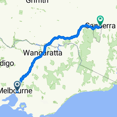 Surrey Hills to Canberra
- Distance
- 646.7 km
- Ascent
- 3,276 m
- Descent
- 2,830 m
- Location
- Surrey Hills, Victoria, Australia
 Home to work
- Distance
- 12.9 km
- Ascent
- 161 m
- Descent
- 201 m
- Location
- Surrey Hills, Victoria, Australia
 Work Short Route
- Distance
- 15.3 km
- Ascent
- 83 m
- Descent
- 163 m
- Location
- Surrey Hills, Victoria, Australia
 Short Route Work
- Distance
- 15.2 km
- Ascent
- 83 m
- Descent
- 163 m
- Location
- Surrey Hills, Victoria, Australia
 Morning Commute
- Distance
- 5.2 km
- Ascent
- 92 m
- Descent
- 118 m
- Location
- Surrey Hills, Victoria, Australia
 Alfred Hospital
- Distance
- 50.2 km
- Ascent
- 396 m
- Descent
- 413 m
- Location
- Surrey Hills, Victoria, Australia
Open it in the app