

MTB Radolfzell-Marienschlucht
A cycling route starting in Radolfzell, Baden-Württemberg, Germany.
Overview
About this route
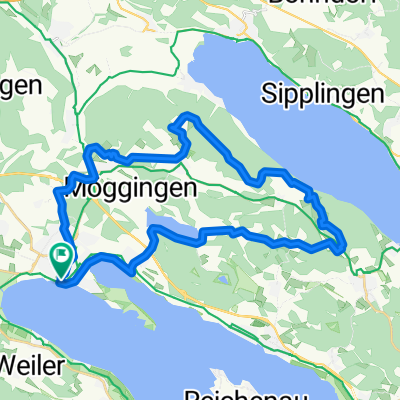
Schöne MTB-Runde mit ewta 35km Länge. Heikel ist die gesperrte Abfahrt von Langenrain bis an den See mit schwierigen Spitzkehren und permanenter Absturzgefahr.
Der für Radfahrer gesperrte Trail von der Marienschlucht nach Wallhausen stellt für geübte MTBler dagegen keine Herausforderung dar - auf Wanderer sollte man jedoch in jedem Fall Rücksicht nehmen. Die Absperrungen an Anfang und Endes des Wanderweges lassen sicht mit dem Rad leicht umgehen.
- -:--
- Duration
- 33.4 km
- Distance
- 500 m
- Ascent
- 500 m
- Descent
- ---
- Avg. speed
- ---
- Avg. speed
Continue with Bikemap
Use, edit, or download this cycling route
You would like to ride MTB Radolfzell-Marienschlucht or customize it for your own trip? Here is what you can do with this Bikemap route:
Free features
- Save this route as favorite or in collections
- Copy & plan your own version of this route
- Sync your route with Garmin or Wahoo
Premium features
Free trial for 3 days, or one-time payment. More about Bikemap Premium.
- Navigate this route on iOS & Android
- Export a GPX / KML file of this route
- Create your custom printout (try it for free)
- Download this route for offline navigation
Discover more Premium features.
Get Bikemap PremiumFrom our community
Other popular routes starting in Radolfzell
 Radolfzell - Lindau / Bodensee
- Distance
- 84.8 km
- Ascent
- 216 m
- Descent
- 215 m
- Location
- Radolfzell, Baden-Württemberg, Germany
 Bodensee-Megathlon 2008 - Rennrad
- Distance
- 52.3 km
- Ascent
- 992 m
- Descent
- 926 m
- Location
- Radolfzell, Baden-Württemberg, Germany
 Strandbadstraße, Radolfzell am Bodensee nach Kanzleistraße, Konstanz
- Distance
- 21.9 km
- Ascent
- 46 m
- Descent
- 44 m
- Location
- Radolfzell, Baden-Württemberg, Germany
 Radolfzell über Meersburg Fähre über Konstanz nach Radolfzell
- Distance
- 73.4 km
- Ascent
- 649 m
- Descent
- 648 m
- Location
- Radolfzell, Baden-Württemberg, Germany
 Bodensee-Megathlon 2008 - MountainBike
- Distance
- 37.2 km
- Ascent
- 499 m
- Descent
- 502 m
- Location
- Radolfzell, Baden-Württemberg, Germany
 Tour über den Bodanrück
- Distance
- 36.1 km
- Ascent
- 546 m
- Descent
- 546 m
- Location
- Radolfzell, Baden-Württemberg, Germany
 Alternativ Bodensee rundweg
- Distance
- 202.3 km
- Ascent
- 260 m
- Descent
- 260 m
- Location
- Radolfzell, Baden-Württemberg, Germany
 Bodensee
- Distance
- 168.9 km
- Ascent
- 435 m
- Descent
- 432 m
- Location
- Radolfzell, Baden-Württemberg, Germany
Open it in the app