

Overview
About this route
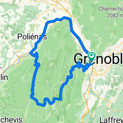
Grenoble - Catania -> Saint-Martin-le-Vinoux (via Oxford Bridge)
Saint-Martin-le-Vinoux -> La Tronche (via the Isère)
La Tronche -> Meylan
Meylan -> Grenoble - Center
Grenoble - Center -> Grenoble - Catania
- -:--
- Duration
- 20.2 km
- Distance
- 65 m
- Ascent
- 68 m
- Descent
- ---
- Avg. speed
- ---
- Max. altitude

Part of
Grenoble
8 stages
Route quality
Waytypes & surfaces along the route
Waytypes
Cycleway
5.9 km
(29 %)
Road
4.2 km
(21 %)
Surfaces
Paved
17.6 km
(87 %)
Unpaved
2.4 km
(12 %)
Asphalt
16.8 km
(83 %)
Loose gravel
1.6 km
(8 %)
Continue with Bikemap
Use, edit, or download this cycling route
You would like to ride Route Fünf or customize it for your own trip? Here is what you can do with this Bikemap route:
Free features
- Save this route as favorite or in collections
- Copy & plan your own version of this route
- Sync your route with Garmin or Wahoo
Premium features
Free trial for 3 days, or one-time payment. More about Bikemap Premium.
- Navigate this route on iOS & Android
- Export a GPX / KML file of this route
- Create your custom printout (try it for free)
- Download this route for offline navigation
Discover more Premium features.
Get Bikemap PremiumFrom our community
Other popular routes starting in Seyssinet-Pariset
 Grenoble 1
- Distance
- 100.3 km
- Ascent
- 2,527 m
- Descent
- 2,528 m
- Location
- Seyssinet-Pariset, Auvergne-Rhône-Alpes, France
 Tour du Néron
- Distance
- 28.7 km
- Ascent
- 528 m
- Descent
- 529 m
- Location
- Seyssinet-Pariset, Auvergne-Rhône-Alpes, France
 Tonyworlds - France
- Distance
- 492 km
- Ascent
- 2,241 m
- Descent
- 2,162 m
- Location
- Seyssinet-Pariset, Auvergne-Rhône-Alpes, France
 Route Vier
- Distance
- 12.4 km
- Ascent
- 58 m
- Descent
- 58 m
- Location
- Seyssinet-Pariset, Auvergne-Rhône-Alpes, France
 Tour de France 2014 - Col de Palaquit - Col de Porte - Col de la Placette
- Distance
- 78.9 km
- Ascent
- 1,357 m
- Descent
- 1,357 m
- Location
- Seyssinet-Pariset, Auvergne-Rhône-Alpes, France
 Route Sechs
- Distance
- 30.2 km
- Ascent
- 60 m
- Descent
- 62 m
- Location
- Seyssinet-Pariset, Auvergne-Rhône-Alpes, France
 berges
- Distance
- 51.6 km
- Ascent
- 37 m
- Descent
- 37 m
- Location
- Seyssinet-Pariset, Auvergne-Rhône-Alpes, France
 Grenoble Domène Revel
- Distance
- 40.8 km
- Ascent
- 637 m
- Descent
- 639 m
- Location
- Seyssinet-Pariset, Auvergne-Rhône-Alpes, France
Open it in the app