
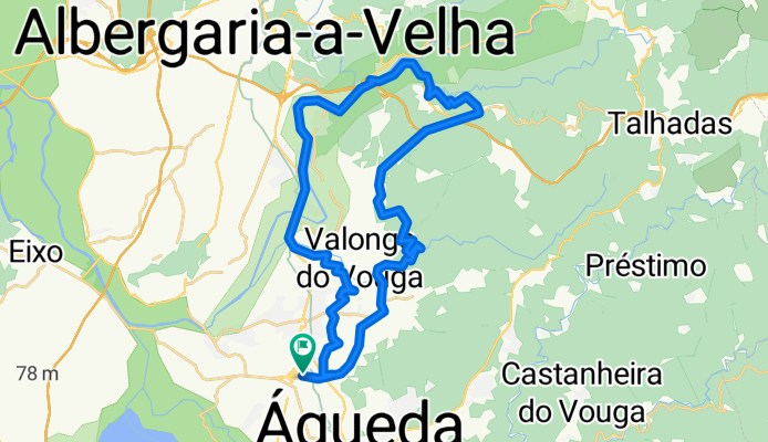
tour Vale do Vouga
A cycling route starting in Águeda Municipality, Aveiro District, Portugal.
Overview
About this route
Confortable Route through the hills around Agueda. 2 or 3 good climbing moments, and also some good downhill.
- -:--
- Duration
- 39.4 km
- Distance
- 436 m
- Ascent
- 436 m
- Descent
- ---
- Avg. speed
- ---
- Max. altitude

Continue with Bikemap
Use, edit, or download this cycling route
You would like to ride tour Vale do Vouga or customize it for your own trip? Here is what you can do with this Bikemap route:
Free features
- Save this route as favorite or in collections
- Copy & plan your own version of this route
- Sync your route with Garmin or Wahoo
Premium features
Free trial for 3 days, or one-time payment. More about Bikemap Premium.
- Navigate this route on iOS & Android
- Export a GPX / KML file of this route
- Create your custom printout (try it for free)
- Download this route for offline navigation
Discover more Premium features.
Get Bikemap PremiumFrom our community
Other popular routes starting in Águeda Municipality
 tour Vale do Vouga
- Distance
- 39.4 km
- Ascent
- 436 m
- Descent
- 436 m
- Location
- Águeda Municipality, Aveiro District, Portugal
 bike tour from Águeda to Aveiro
- Distance
- 21.2 km
- Ascent
- 111 m
- Descent
- 105 m
- Location
- Águeda Municipality, Aveiro District, Portugal
 #1 𝘼𝙣𝙖 𝘽𝙚𝙖𝙩𝙧𝙞𝙯 𝕀𝕔𝕖𝔹𝕝𝕦𝕖 11/10/2020
- Distance
- 12.9 km
- Ascent
- 211 m
- Descent
- 211 m
- Location
- Águeda Municipality, Aveiro District, Portugal
 Águeda Pombal
- Distance
- 101.2 km
- Ascent
- 433 m
- Descent
- 430 m
- Location
- Águeda Municipality, Aveiro District, Portugal
 Talhadas, Caramulo
- Distance
- 77.3 km
- Ascent
- 1,559 m
- Descent
- 1,559 m
- Location
- Águeda Municipality, Aveiro District, Portugal
 Agueda - Barcelos
- Distance
- 129.3 km
- Ascent
- 994 m
- Descent
- 986 m
- Location
- Águeda Municipality, Aveiro District, Portugal
 𝘼𝙣𝙖 𝘽𝙚𝙖𝙩𝙧𝙞𝙯 𝕀𝕔𝕖𝔹𝕝𝕦𝕖 18/04/2021
- Distance
- 19.6 km
- Ascent
- 297 m
- Descent
- 297 m
- Location
- Águeda Municipality, Aveiro District, Portugal
 Day #7 Agueda to Porto
- Distance
- 83 km
- Ascent
- 441 m
- Descent
- 388 m
- Location
- Águeda Municipality, Aveiro District, Portugal
Open it in the app