

Tour: Iron Curtain Germany (ridden 2020)
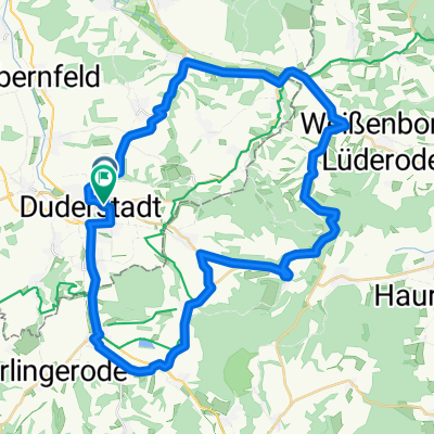
Grünes Band DE 10/14: Duderstadt - Hornburg
A cycling route starting in Duderstadt, Lower Saxony, Germany.
Overview
About this route
25.05.2020 (Mo.) Duderstadt - Fuhrbach - Brochthausen - Bockelnhagen - Weilrode - Limlingerode - Mackenrode - Tettenborn - Walkenried - Ellrich - Zorge - Hohegeiß - Sorge - Elend - Drei Annen Hohne - Wernigerode - Drübeck - Ilsenburg (Harz) - Stapelburg - Abbenrode - Wülperode - Hornburg
It is a part of the route »Iron Curtain Germany«. All Routes in Collection: »Tour: Grünes Band Deutschland«
← (previous) Grünes Band DE 09/14: Lindewerra - Duderstadt
→ (next) Grünes Band DE 11/14: Hornburg - Jübar
Strecke: 112,64 km | Fahrzeit: 7:49 Std | ø Geschwindigkeit: 14,39 km/h | max. Geschwindigkeit: 50,51 km/h
- -:--
- Duration
- 106.1 km
- Distance
- 1,450 m
- Ascent
- 1,541 m
- Descent
- ---
- Avg. speed
- ---
- Max. altitude

Part of
Route photos


Route quality
Waytypes & surfaces along the route
Waytypes
Busy road
48.7 km
(46 %)
Path
20.6 km
(19 %)
Surfaces
Paved
92.6 km
(87 %)
Unpaved
1.8 km
(2 %)
Asphalt
79.8 km
(75 %)
Paving stones
11.3 km
(11 %)
Route highlights
Points of interest along the route

Photo after 0.3 km
Duderstadt (schöne Altstadt)

Photo after 35 km
Drinking water after 35.3 km
Bäcker + Kaffee
Point of interest after 46.5 km
Bergauf zum Bergdorf Hohegeiß

Photo after 47.7 km
sieht überhaupt nicht nach berauf aus.

Photo after 50.2 km
Kolonnenweg - sehr unangenehm zum Fahrradfahren.
Point of interest after 52.1 km
Sehr, sehr steil (!)
Drinking water after 61.6 km
Restaurant + Hotel 'Waldmühle'
Point of interest after 63.9 km
Beginn einer langen Abfahrt nach Wernigerode.
Drinking water after 68.5 km
Kukki´s Erbsensuppe www.kukki.de

Point of interest after 78.1 km
Rathaus von Wernigerode
Drinking water after 98 km
Grenz-Kaschemme

Point of interest after 99.6 km
Grenz-Kunst. Im Hintergrund der Harz.

Point of interest after 103.8 km
ehemalige Grenze bei Hornburg
Continue with Bikemap
Use, edit, or download this cycling route
You would like to ride Grünes Band DE 10/14: Duderstadt - Hornburg or customize it for your own trip? Here is what you can do with this Bikemap route:
Free features
- Save this route as favorite or in collections
- Copy & plan your own version of this route
- Split it into stages to create a multi-day tour
- Sync your route with Garmin or Wahoo
Premium features
Free trial for 3 days, or one-time payment. More about Bikemap Premium.
- Navigate this route on iOS & Android
- Export a GPX / KML file of this route
- Create your custom printout (try it for free)
- Download this route for offline navigation
Discover more Premium features.
Get Bikemap PremiumFrom our community
Other popular routes starting in Duderstadt
 Teistungen Sonnenstein
- Distance
- 41.1 km
- Ascent
- 397 m
- Descent
- 385 m
- Location
- Duderstadt, Lower Saxony, Germany
 Eichsfelder Hügelrunde
- Distance
- 42 km
- Ascent
- 446 m
- Descent
- 442 m
- Location
- Duderstadt, Lower Saxony, Germany
 Hemahrt Duderstadt-Ronnenberg
- Distance
- 126 km
- Ascent
- 358 m
- Descent
- 476 m
- Location
- Duderstadt, Lower Saxony, Germany
 Duathlon: 2. Fahrradstrecke
- Distance
- 7.9 km
- Ascent
- 59 m
- Descent
- 75 m
- Location
- Duderstadt, Lower Saxony, Germany
 Sonnenstein -Sielmann Rundkurs
- Distance
- 23.1 km
- Ascent
- 289 m
- Descent
- 289 m
- Location
- Duderstadt, Lower Saxony, Germany
 Erkundung Obereichsfeld
- Distance
- 56.7 km
- Ascent
- 881 m
- Descent
- 881 m
- Location
- Duderstadt, Lower Saxony, Germany
 BURG SCHAFENSTEIN
- Distance
- 44.5 km
- Ascent
- 499 m
- Descent
- 495 m
- Location
- Duderstadt, Lower Saxony, Germany
 Duderstadt-Sonnenstein-Fuhrbach Rundfahrt
- Distance
- 27.1 km
- Ascent
- 396 m
- Descent
- 330 m
- Location
- Duderstadt, Lower Saxony, Germany
Open it in the app