
Tour: Wien-Bratislava-Praha-Berlin-Hamburg (ridden 2016)
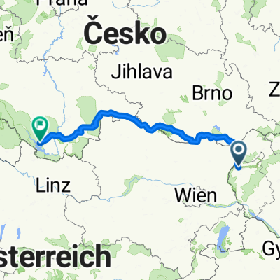
Wien-Hamburg 02/10: Gajary (SVK) - Vrbovec (bei Znojmo) (CZE)
A cycling route starting in Malacky, Bratislava Region, Slovakia.
Overview
About this route
27.04.2016 (Mi.) Gajary (SVK) - Grenzübergang CZE 425 Lanžhot/SVK 425 Brodské - Castle Pohansko - Valtice - Sedlec - Mikulov - Nový Přerov - Hevlín - Jaroslavice - Vrbovec (bei Znojmo)
It is a part of the »Tour: Wien-Bratislava-Praha-Berlin-Hamburg«
← (previous) Wien-Hamburg 01/10: Wien - Bratislava - Gajary
→ (next) Wien-Hamburg 03/10: Vrbovec (bei Znojmo) - Slavonice
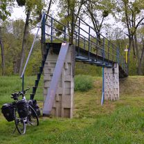
Die Abbiegung zur Fahrrad- und Fussgänger-Brücke über die Myjava ist am Fahrradweg am Deich nicht beschildert! Die Brücke ist steil und das Rad muss getragen werden (s. Foto). Nach der Ortschaft Valtice (CZE) fährt man auf dem gut ausgebauten, beschilderten und GPS-erfassten Greenway "Wien-Prag".
GPS-Daten:
Strecke: 134,49 km
Fahrzeit: 7:07 Std
ø Geschwindigkeit: 18,86 km/h
max. Geschwindigkeit: 38,43 km/h
- -:--
- Duration
- 136.3 km
- Distance
- 762 m
- Ascent
- 697 m
- Descent
- ---
- Avg. speed
- ---
- Max. altitude

Part of
Route photos
 - Vrbovec (bei Znojmo) (CZE)\"")
 - Vrbovec (bei Znojmo) (CZE)\"")
 - Vrbovec (bei Znojmo) (CZE)\"")
 - Vrbovec (bei Znojmo) (CZE)\"")
 - Vrbovec (bei Znojmo) (CZE)\"")
 - Vrbovec (bei Znojmo) (CZE)\"")
 - Vrbovec (bei Znojmo) (CZE)\"")
 - Vrbovec (bei Znojmo) (CZE)\"")
Route quality
Waytypes & surfaces along the route
Waytypes
Track
58.6 km
(43 %)
Road
32.7 km
(24 %)
Surfaces
Paved
84.5 km
(62 %)
Unpaved
27.3 km
(20 %)
Asphalt
79.1 km
(58 %)
Gravel
25.9 km
(19 %)
Route highlights
Points of interest along the route
Accommodation after 0 km
Ubytovňa Záhoran https://www.megaubytovanie.sk/ubytovna-zahoran
 - Vrbovec (bei Znojmo) (CZE)\"")
Photo after 25.6 km
Fussgänger-Brücke ü. Myjava
 - Vrbovec (bei Znojmo) (CZE)\"")
Photo after 30.7 km
Grenze SVK/CZE
 - Vrbovec (bei Znojmo) (CZE)\"")
Photo after 42.6 km
Castle Pohansko
Point of interest after 50.7 km
(i) Scharf links abbiegen! Man kann es schon mal übersehen ;)
Drinking water after 62.1 km
Bier-Pause und Essen.
 - Vrbovec (bei Znojmo) (CZE)\"")
Photo after 69.2 km
Vino-Pause
 - Vrbovec (bei Znojmo) (CZE)\"")
Photo after 69.7 km
Greenway Praha-Wien und Viniarske Cyklostezki
 - Vrbovec (bei Znojmo) (CZE)\"")
Photo after 78.3 km
Blick auf Mikulov
Point of interest after 97.1 km
(i) Hier besser links abbiegen.
Drinking water after 113.9 km
Bier-Pause in der Dorf-Knajpe
 - Vrbovec (bei Znojmo) (CZE)\"")
Photo after 124.3 km
Wassermühle Slup
 - Vrbovec (bei Znojmo) (CZE)\"")
Accommodation after 136.2 km
Pension "Retro" https://www.penzionvrbovec.cz
Continue with Bikemap
Use, edit, or download this cycling route
You would like to ride Wien-Hamburg 02/10: Gajary (SVK) - Vrbovec (bei Znojmo) (CZE) or customize it for your own trip? Here is what you can do with this Bikemap route:
Free features
- Save this route as favorite or in collections
- Copy & plan your own version of this route
- Split it into stages to create a multi-day tour
- Sync your route with Garmin or Wahoo
Premium features
Free trial for 3 days, or one-time payment. More about Bikemap Premium.
- Navigate this route on iOS & Android
- Export a GPX / KML file of this route
- Create your custom printout (try it for free)
- Download this route for offline navigation
Discover more Premium features.
Get Bikemap PremiumFrom our community
Other popular routes starting in Malacky
 Záhorácka do Záhorácka
- Distance
- 12.2 km
- Ascent
- 51 m
- Descent
- 103 m
- Location
- Malacky, Bratislava Region, Slovakia
 Wien-Hamburg 02/10: Gajary (SVK) - Vrbovec (bei Znojmo) (CZE)
- Distance
- 136.3 km
- Ascent
- 762 m
- Descent
- 697 m
- Location
- Malacky, Bratislava Region, Slovakia
 Nedelna siesta v Karpatoch
- Distance
- 65.3 km
- Ascent
- 587 m
- Descent
- 587 m
- Location
- Malacky, Bratislava Region, Slovakia
 vyslap 4 - Rudava back home
- Distance
- 49.9 km
- Ascent
- 179 m
- Descent
- 143 m
- Location
- Malacky, Bratislava Region, Slovakia
 Duklianskych hrdinov 16 do Duk. hrdinov 6A
- Distance
- 30.5 km
- Ascent
- 104 m
- Descent
- 101 m
- Location
- Malacky, Bratislava Region, Slovakia
 Biely kriz, Kacin, Zohor
- Distance
- 63 km
- Ascent
- 698 m
- Descent
- 703 m
- Location
- Malacky, Bratislava Region, Slovakia
 Gajary_Devín
- Distance
- 49.2 km
- Ascent
- 61 m
- Descent
- 66 m
- Location
- Malacky, Bratislava Region, Slovakia
 Šumava 2008:V.Leváre-Černá v Pošumaví
- Distance
- 322.5 km
- Ascent
- 2,383 m
- Descent
- 1,973 m
- Location
- Malacky, Bratislava Region, Slovakia
Open it in the app