

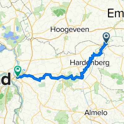
Coevorden - Bad Bentheim
A cycling route starting in Coevorden, Drenthe, The Netherlands.
Overview
About this route
Coevorden - Bad Bentheim - ca. 75 km
auf ausgewiesenen Routen der Grafschafter Fietsentour und der Vechtetalroute mit kunstwegen
Coevorden - Coevorden-Piccardie-Kanal - Vorwald . Vechte-Kurbelfähre "Fähr Harm" in Echteler - Wilsum - Uelser Berg - Bronzezeithof Uelsen - Windmühle Uelsen - Uelsen - Nordbecks Mühle - Lage, Teestube, Burgruine, Eichenalllee - . Reiherhorst - Reitgaar - Kloster Frenswegen - Vechte - Nordhorn, Stadtpark, Europaplatz, Vechtesee - Tierpark - Hesepe - Brandlecht - Bahnhof Hestrup - Quendorf - Kurzentrum Bad Bentheim - Bad Bentheim
- -:--
- Duration
- 75 km
- Distance
- 148 m
- Ascent
- 91 m
- Descent
- ---
- Avg. speed
- ---
- Max. altitude
Route quality
Waytypes & surfaces along the route
Waytypes
Quiet road
46.5 km
(62 %)
Path
13.5 km
(18 %)
Surfaces
Paved
36.8 km
(49 %)
Unpaved
9.8 km
(13 %)
Asphalt
26.3 km
(35 %)
Paved (undefined)
10.5 km
(14 %)
Continue with Bikemap
Use, edit, or download this cycling route
You would like to ride Coevorden - Bad Bentheim or customize it for your own trip? Here is what you can do with this Bikemap route:
Free features
- Save this route as favorite or in collections
- Copy & plan your own version of this route
- Sync your route with Garmin or Wahoo
Premium features
Free trial for 3 days, or one-time payment. More about Bikemap Premium.
- Navigate this route on iOS & Android
- Export a GPX / KML file of this route
- Create your custom printout (try it for free)
- Download this route for offline navigation
Discover more Premium features.
Get Bikemap PremiumFrom our community
Other popular routes starting in Coevorden
 Coeverse Heuveltocht 118km
- Distance
- 118.1 km
- Ascent
- 242 m
- Descent
- 240 m
- Location
- Coevorden, Drenthe, The Netherlands
 Coevorden - Bad Bentheim
- Distance
- 75 km
- Ascent
- 148 m
- Descent
- 91 m
- Location
- Coevorden, Drenthe, The Netherlands
 LangsDeDrentseGrenzen 306 km
- Distance
- 306.1 km
- Ascent
- 256 m
- Descent
- 254 m
- Location
- Coevorden, Drenthe, The Netherlands
 Coevorden to Werlte
- Distance
- 78.8 km
- Ascent
- 188 m
- Descent
- 163 m
- Location
- Coevorden, Drenthe, The Netherlands
 Journalistenreise 5.-7.07.13 Variante 1
- Distance
- 46.6 km
- Ascent
- 28 m
- Descent
- 26 m
- Location
- Coevorden, Drenthe, The Netherlands
 Rondje Coevorden-Nieuwlande-Dalen
- Distance
- 35.3 km
- Ascent
- 17 m
- Descent
- 17 m
- Location
- Coevorden, Drenthe, The Netherlands
 Spoorhavenstraat 23, Coevorden do Gramsbergerstraat 47, Coevorden
- Distance
- 2 km
- Ascent
- 0 m
- Descent
- 0 m
- Location
- Coevorden, Drenthe, The Netherlands
 Familienradler 2022 3. Tag
- Distance
- 72.1 km
- Ascent
- 170 m
- Descent
- 181 m
- Location
- Coevorden, Drenthe, The Netherlands
Open it in the app