

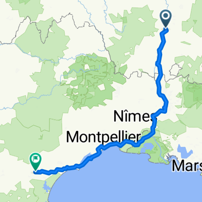
Beauchastel - Pont-Saint-Esprit
A cycling route starting in Beauchastel, Auvergne-Rhône-Alpes, France.
Overview
About this route
Camping des ponts
220 Chemin du Pont Cassé, 07700 Saint-Just-d'Ardèche 06 80 45 09 15
- -:--
- Duration
- 81.5 km
- Distance
- 145 m
- Ascent
- 194 m
- Descent
- ---
- Avg. speed
- ---
- Avg. speed

Route quality
Waytypes & surfaces along the route
Waytypes
Cycleway
41.9 km
(51 %)
Quiet road
21.8 km
(27 %)
Surfaces
Paved
56.6 km
(69 %)
Unpaved
1.9 km
(2 %)
Asphalt
55.2 km
(68 %)
Loose gravel
1.5 km
(2 %)
Continue with Bikemap
Use, edit, or download this cycling route
You would like to ride Beauchastel - Pont-Saint-Esprit or customize it for your own trip? Here is what you can do with this Bikemap route:
Free features
- Save this route as favorite or in collections
- Copy & plan your own version of this route
- Sync your route with Garmin or Wahoo
Premium features
Free trial for 3 days, or one-time payment. More about Bikemap Premium.
- Navigate this route on iOS & Android
- Export a GPX / KML file of this route
- Create your custom printout (try it for free)
- Download this route for offline navigation
Discover more Premium features.
Get Bikemap PremiumFrom our community
Other popular routes starting in Beauchastel
 Höllentrip ans Ende Europas 1150-1500km
- Distance
- 350 km
- Ascent
- 206 m
- Descent
- 268 m
- Location
- Beauchastel, Auvergne-Rhône-Alpes, France
 dernière ligne droite
- Distance
- 17.4 km
- Ascent
- 349 m
- Descent
- 38 m
- Location
- Beauchastel, Auvergne-Rhône-Alpes, France
 Beauchastel - Pont-Saint-Esprit
- Distance
- 81.5 km
- Ascent
- 145 m
- Descent
- 194 m
- Location
- Beauchastel, Auvergne-Rhône-Alpes, France
 2o16-10-30 voie douce de Privas Chomérac
- Distance
- 45.6 km
- Ascent
- 199 m
- Descent
- 164 m
- Location
- Beauchastel, Auvergne-Rhône-Alpes, France
 VB to Olières
- Distance
- 17.9 km
- Ascent
- 173 m
- Descent
- 69 m
- Location
- Beauchastel, Auvergne-Rhône-Alpes, France
 Via Rhona, Beauchastel nach Chemin de la Payré, Baix
- Distance
- 16.1 km
- Ascent
- 61 m
- Descent
- 78 m
- Location
- Beauchastel, Auvergne-Rhône-Alpes, France
 6 Route du Pont, Beauchastel naar 1 Chemin des Sportifs, Soyons
- Distance
- 12.8 km
- Ascent
- 69 m
- Descent
- 59 m
- Location
- Beauchastel, Auvergne-Rhône-Alpes, France
 La Voulte - Le Puy
- Distance
- 127 km
- Ascent
- 1,652 m
- Descent
- 1,155 m
- Location
- Beauchastel, Auvergne-Rhône-Alpes, France
Open it in the app