
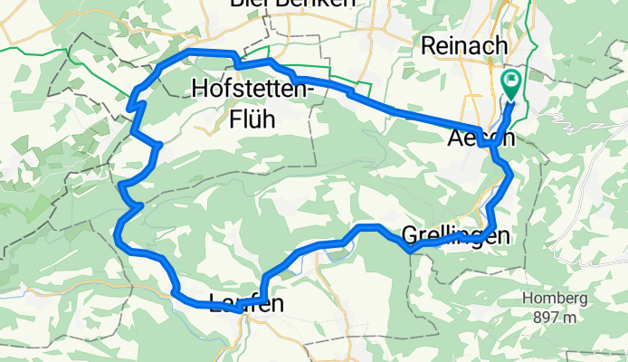
Chalhöhe via Rodersdorf
A cycling route starting in Dornach, Canton of Solothurn, Switzerland.
Overview
About this route
- -:--
- Duration
- 41.1 km
- Distance
- 634 m
- Ascent
- 634 m
- Descent
- ---
- Avg. speed
- ---
- Max. altitude

Route quality
Waytypes & surfaces along the route
Waytypes
Busy road
24.1 km
(59 %)
Quiet road
6.3 km
(15 %)
Surfaces
Paved
14.3 km
(35 %)
Unpaved
2.7 km
(7 %)
Asphalt
14.3 km
(35 %)
Gravel
1.5 km
(4 %)
Continue with Bikemap
Use, edit, or download this cycling route
You would like to ride Chalhöhe via Rodersdorf or customize it for your own trip? Here is what you can do with this Bikemap route:
Free features
- Save this route as favorite or in collections
- Copy & plan your own version of this route
- Sync your route with Garmin or Wahoo
Premium features
Free trial for 3 days, or one-time payment. More about Bikemap Premium.
- Navigate this route on iOS & Android
- Export a GPX / KML file of this route
- Create your custom printout (try it for free)
- Download this route for offline navigation
Discover more Premium features.
Get Bikemap PremiumFrom our community
Other popular routes starting in Dornach
 Ruedi Tour
- Distance
- 79.1 km
- Ascent
- 930 m
- Descent
- 963 m
- Location
- Dornach, Canton of Solothurn, Switzerland
 Fahrt ins Thierstein
- Distance
- 44.8 km
- Ascent
- 573 m
- Descent
- 536 m
- Location
- Dornach, Canton of Solothurn, Switzerland
 Leichte Feierabendrunde
- Distance
- 29.6 km
- Ascent
- 354 m
- Descent
- 352 m
- Location
- Dornach, Canton of Solothurn, Switzerland
 Baselbieterrundfahrt
- Distance
- 93.3 km
- Ascent
- 1,203 m
- Descent
- 1,209 m
- Location
- Dornach, Canton of Solothurn, Switzerland
 Rund um den Gempen 2
- Distance
- 48.9 km
- Ascent
- 508 m
- Descent
- 457 m
- Location
- Dornach, Canton of Solothurn, Switzerland
 Rund um den Gempen
- Distance
- 43.4 km
- Ascent
- 649 m
- Descent
- 610 m
- Location
- Dornach, Canton of Solothurn, Switzerland
 Gempen Strecke
- Distance
- 5.1 km
- Ascent
- 297 m
- Descent
- 0 m
- Location
- Dornach, Canton of Solothurn, Switzerland
 Dornach Mältigerbärg Seewe Gämpe Heim
- Distance
- 62.2 km
- Ascent
- 846 m
- Descent
- 810 m
- Location
- Dornach, Canton of Solothurn, Switzerland
Open it in the app