

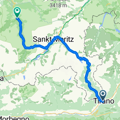
test Mountain pass eror 2
A cycling route starting in Tirano, Lombardy, Italy.
Overview
About this route
- -:--
- Duration
- 119.2 km
- Distance
- 4,227 m
- Ascent
- 2,084 m
- Descent
- ---
- Avg. speed
- ---
- Max. altitude

Route quality
Waytypes & surfaces along the route
Waytypes
Quiet road
25 km
(21 %)
Track
14.3 km
(12 %)
Surfaces
Paved
88.2 km
(74 %)
Unpaved
13.1 km
(11 %)
Asphalt
88.2 km
(74 %)
Gravel
9.5 km
(8 %)
Continue with Bikemap
Use, edit, or download this cycling route
You would like to ride test Mountain pass eror 2 or customize it for your own trip? Here is what you can do with this Bikemap route:
Free features
- Save this route as favorite or in collections
- Copy & plan your own version of this route
- Split it into stages to create a multi-day tour
- Sync your route with Garmin or Wahoo
Premium features
Free trial for 3 days, or one-time payment. More about Bikemap Premium.
- Navigate this route on iOS & Android
- Export a GPX / KML file of this route
- Create your custom printout (try it for free)
- Download this route for offline navigation
Discover more Premium features.
Get Bikemap PremiumFrom our community
Other popular routes starting in Tirano
 2010 podjazd do Sondalo
- Distance
- 21.5 km
- Ascent
- 522 m
- Descent
- 37 m
- Location
- Tirano, Lombardy, Italy
 VSLG2025 3. Tag Tirano nach Savognin
- Distance
- 101.8 km
- Ascent
- 3,760 m
- Descent
- 2,984 m
- Location
- Tirano, Lombardy, Italy
 Giro d'Italia 2015 - Stage 17
- Distance
- 137.3 km
- Ascent
- 858 m
- Descent
- 1,020 m
- Location
- Tirano, Lombardy, Italy
 Tirano - Samedan
- Distance
- 57 km
- Ascent
- 1,936 m
- Descent
- 635 m
- Location
- Tirano, Lombardy, Italy
 Tirano - Bernina - Stelvio
- Distance
- 233.3 km
- Ascent
- 4,217 m
- Descent
- 4,217 m
- Location
- Tirano, Lombardy, Italy
 Tirano - Savognin
- Distance
- 100.9 km
- Ascent
- 3,732 m
- Descent
- 2,962 m
- Location
- Tirano, Lombardy, Italy
 test Mountain pass eror 2
- Distance
- 119.2 km
- Ascent
- 4,227 m
- Descent
- 2,084 m
- Location
- Tirano, Lombardy, Italy
 6 - Tirano - Passo Rombo
- Distance
- 311.2 km
- Ascent
- 6,618 m
- Descent
- 4,583 m
- Location
- Tirano, Lombardy, Italy
Open it in the app