

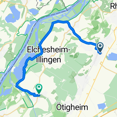
DuEtMoosalbRiMaDu
A cycling route starting in Durmersheim, Baden-Wurttemberg, Germany.
Overview
About this route
- -:--
- Duration
- 45.4 km
- Distance
- 349 m
- Ascent
- 347 m
- Descent
- ---
- Avg. speed
- ---
- Max. altitude

Route quality
Waytypes & surfaces along the route
Waytypes
Track
28.6 km
(63 %)
Quiet road
8.2 km
(18 %)
Surfaces
Paved
20.4 km
(45 %)
Unpaved
21.8 km
(48 %)
Asphalt
15 km
(33 %)
Gravel
14.5 km
(32 %)
Route highlights
Points of interest along the route
Point of interest after 32.3 km
Malschauen
Continue with Bikemap
Use, edit, or download this cycling route
You would like to ride DuEtMoosalbRiMaDu or customize it for your own trip? Here is what you can do with this Bikemap route:
Free features
- Save this route as favorite or in collections
- Copy & plan your own version of this route
- Sync your route with Garmin or Wahoo
Premium features
Free trial for 3 days, or one-time payment. More about Bikemap Premium.
- Navigate this route on iOS & Android
- Export a GPX / KML file of this route
- Create your custom printout (try it for free)
- Download this route for offline navigation
Discover more Premium features.
Get Bikemap PremiumFrom our community
Other popular routes starting in Durmersheim
 Stadtradeln: MTB -Tour rund um Durmersheim/Würmersheim
- Distance
- 15.2 km
- Ascent
- 58 m
- Descent
- 57 m
- Location
- Durmersheim, Baden-Wurttemberg, Germany
 Sommertour Thomas
- Distance
- 16 km
- Ascent
- 15 m
- Descent
- 23 m
- Location
- Durmersheim, Baden-Wurttemberg, Germany
 Durmersheim - Ebersteinburg-WeißerStein-Malsch-Durmersheim
- Distance
- 50.4 km
- Ascent
- 547 m
- Descent
- 548 m
- Location
- Durmersheim, Baden-Wurttemberg, Germany
 Würmerheim - Staustufe Iffezheim - Reheinbrücke Wintersdorf - Durmersheim
- Distance
- 43.5 km
- Ascent
- 113 m
- Descent
- 99 m
- Location
- Durmersheim, Baden-Wurttemberg, Germany
 Stadtradeln - Rund um Durmersheim
- Distance
- 20 km
- Ascent
- 65 m
- Descent
- 63 m
- Location
- Durmersheim, Baden-Wurttemberg, Germany
 Stadtradeln: Tour durch den Gemeindeverwaltungsverband Durmersheim
- Distance
- 17.5 km
- Ascent
- 43 m
- Descent
- 42 m
- Location
- Durmersheim, Baden-Wurttemberg, Germany
 Tal- und Saumweg
- Distance
- 44.3 km
- Ascent
- 335 m
- Descent
- 335 m
- Location
- Durmersheim, Baden-Wurttemberg, Germany
 Von Würmersheim um den Fermasee in Neuburgweier
- Distance
- 17.5 km
- Ascent
- 18 m
- Descent
- 68 m
- Location
- Durmersheim, Baden-Wurttemberg, Germany
Open it in the app