
Tour: Iron Curtain Germany (ridden 2020)
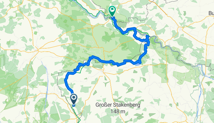
Grünes Band DE 12/14: Jübar - Dömitz
A cycling route starting in Jübar, Saxony-Anhalt, Germany.
Overview
About this route
27.05.2020 (Mi.) Jübar - Diesdorf - Bonese - Dahrendorf - Bergen an der Dumme - Seeben - Wustrow - Volzendorf - Schmarsau - Zießau - Gollensdorf - Bömenzien - Schnackenburg - Kapern - Gartow - Restorf - Pevestorf - Lenzen (Fähre) - Kietz - Unbesandten - Besandten - Dömitz
It is a part of the route »Iron Curtain Germany«. All Routes in Collection: »Tour: Grünes Band Deutschland«
← (previous) Grünes Band DE 11/14: Hornburg - Jübar
→ (next) Grünes Band DE 13/14: Dömitz - Zarrentin am Schaalsee
Strecke: 145,04 km | Fahrzeit: 8:20 Std | ø Geschwindigkeit: 17,40 km/h | max. Geschwindigkeit: 39,34 km/h
Fisch-Imbiss "Maränenhof"
- -:--
- Duration
- 140.4 km
- Distance
- 486 m
- Ascent
- 550 m
- Descent
- ---
- Avg. speed
- ---
- Max. altitude

Part of
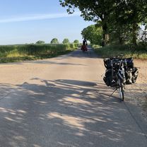
Route photos


Route quality
Waytypes & surfaces along the route
Waytypes
Track
35.1 km
(25 %)
Road
26.7 km
(19 %)
Surfaces
Paved
80 km
(57 %)
Unpaved
19.7 km
(14 %)
Asphalt
63.2 km
(45 %)
Loose gravel
14 km
(10 %)
Route highlights
Points of interest along the route

Photo after 5 km
Altmarkrundkurs

Drinking water after 8.4 km
Bäckerei "Salzwedeler Baumkuchen"
Drinking water after 79 km
Fisch - Imbis Fischerei Kagel https://www.mdr.de/video/mdr-videos/c/video-390464.html
Point of interest after 80.5 km
Info: Sandweg für Bike nicht geeignet.
Point of interest after 100.6 km
Info: Fähre am 27.05.2020 ausserbetrieb.
Drinking water after 115.5 km
Restaurant Hotel

Point of interest after 117.2 km
Info: Fähre

Point of interest after 120.5 km
Kunstwerk: Charon
Drinking water after 139.1 km
Supermarket
Accommodation after 140.4 km
Radlerpension Dömitz https://radlerpension-doemitz-elberadweg.de/
Continue with Bikemap
Use, edit, or download this cycling route
You would like to ride Grünes Band DE 12/14: Jübar - Dömitz or customize it for your own trip? Here is what you can do with this Bikemap route:
Free features
- Save this route as favorite or in collections
- Copy & plan your own version of this route
- Split it into stages to create a multi-day tour
- Sync your route with Garmin or Wahoo
Premium features
Free trial for 3 days, or one-time payment. More about Bikemap Premium.
- Navigate this route on iOS & Android
- Export a GPX / KML file of this route
- Create your custom printout (try it for free)
- Download this route for offline navigation
Discover more Premium features.
Get Bikemap PremiumFrom our community
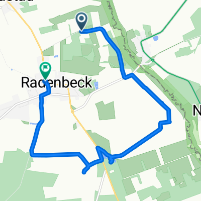
Other popular routes starting in Jübar
 Plastauer Straße 12, Wittingen nach Niedersachsenring 6, Wittingen
- Distance
- 26.1 km
- Ascent
- 79 m
- Descent
- 77 m
- Location
- Jübar, Saxony-Anhalt, Germany
 Grünes Band DE 12/14: Jübar - Dömitz
- Distance
- 140.4 km
- Ascent
- 486 m
- Descent
- 550 m
- Location
- Jübar, Saxony-Anhalt, Germany
 Plastauer Straße 14, Wittingen nach B244 12, Wittingen
- Distance
- 34.9 km
- Ascent
- 89 m
- Descent
- 135 m
- Location
- Jübar, Saxony-Anhalt, Germany
 Plastauer Straße 14, Wittingen nach B244 12, Wittingen
- Distance
- 33.3 km
- Ascent
- 70 m
- Descent
- 114 m
- Location
- Jübar, Saxony-Anhalt, Germany
 Breite Straße 2, Jübar nach Breite Straße 2, Jübar
- Distance
- 12.2 km
- Ascent
- 222 m
- Descent
- 250 m
- Location
- Jübar, Saxony-Anhalt, Germany
 Jübar - Magdeburg
- Distance
- 97.2 km
- Ascent
- 69 m
- Descent
- 88 m
- Location
- Jübar, Saxony-Anhalt, Germany
 lange Route 1
- Distance
- 7.5 km
- Ascent
- 39 m
- Descent
- 13 m
- Location
- Jübar, Saxony-Anhalt, Germany
 Rund um Brome
- Distance
- 48.7 km
- Ascent
- 113 m
- Descent
- 117 m
- Location
- Jübar, Saxony-Anhalt, Germany
Open it in the app