
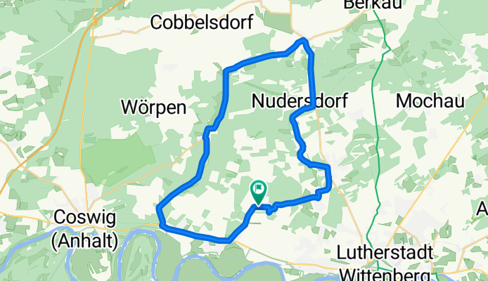
Apollensdorf Nord-Straach-Griebo-Apollensdorf Nord
A cycling route starting in Nudersdorf, Saxony-Anhalt, Germany.
Overview
About this route
- -:--
- Duration
- 28.7 km
- Distance
- 114 m
- Ascent
- 116 m
- Descent
- ---
- Avg. speed
- ---
- Max. altitude

Route quality
Waytypes & surfaces along the route
Waytypes
Quiet road
5.7 km
(20 %)
Path
4.6 km
(16 %)
Surfaces
Paved
15.2 km
(53 %)
Unpaved
4 km
(14 %)
Asphalt
14.9 km
(52 %)
Ground
3.7 km
(13 %)
Route highlights
Points of interest along the route
Point of interest after 18.8 km
Diese Strecke durch den Wald nur mit Mountenbike.
Continue with Bikemap
Use, edit, or download this cycling route
You would like to ride Apollensdorf Nord-Straach-Griebo-Apollensdorf Nord or customize it for your own trip? Here is what you can do with this Bikemap route:
Free features
- Save this route as favorite or in collections
- Copy & plan your own version of this route
- Sync your route with Garmin or Wahoo
Premium features
Free trial for 3 days, or one-time payment. More about Bikemap Premium.
- Navigate this route on iOS & Android
- Export a GPX / KML file of this route
- Create your custom printout (try it for free)
- Download this route for offline navigation
Discover more Premium features.
Get Bikemap PremiumFrom our community
Other popular routes starting in Nudersdorf
 Apollensdorf Nord-Straach-Griebo-Apollensdorf Nord
- Distance
- 28.7 km
- Ascent
- 114 m
- Descent
- 116 m
- Location
- Nudersdorf, Saxony-Anhalt, Germany
 Am Teich 3, Lutherstadt Wittenberg nach Am Teich 3, Lutherstadt Wittenberg
- Distance
- 10.5 km
- Ascent
- 155 m
- Descent
- 195 m
- Location
- Nudersdorf, Saxony-Anhalt, Germany
 SoRiRa 2025 Tag 1.3
- Distance
- 15.8 km
- Ascent
- 97 m
- Descent
- 148 m
- Location
- Nudersdorf, Saxony-Anhalt, Germany
 Kleine Flämingrunde
- Distance
- 37 km
- Ascent
- 199 m
- Descent
- 199 m
- Location
- Nudersdorf, Saxony-Anhalt, Germany
 Europaradweg R1
- Distance
- 265.2 km
- Ascent
- 645 m
- Descent
- 769 m
- Location
- Nudersdorf, Saxony-Anhalt, Germany
 Wittenberg - Trebbin
- Distance
- 74.2 km
- Ascent
- 211 m
- Descent
- 264 m
- Location
- Nudersdorf, Saxony-Anhalt, Germany
 K2011, Lutherstadt Wittenberg nach Straße ohne Straßennamen, Zabakuck
- Distance
- 96.3 km
- Ascent
- 482 m
- Descent
- 587 m
- Location
- Nudersdorf, Saxony-Anhalt, Germany
 home1
home1- Distance
- 56 km
- Ascent
- 179 m
- Descent
- 180 m
- Location
- Nudersdorf, Saxony-Anhalt, Germany
Open it in the app