
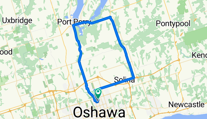
Port Perry - Blackstock
A cycling route starting in Oshawa, Ontario, Canada.
Overview
About this route
- -:--
- Duration
- 61.7 km
- Distance
- 337 m
- Ascent
- 330 m
- Descent
- ---
- Avg. speed
- ---
- Max. altitude

Route quality
Waytypes & surfaces along the route
Waytypes
Busy road
28.2 km
(46 %)
Road
22.4 km
(36 %)
Surfaces
Paved
56.2 km
(91 %)
Asphalt
56.1 km
(91 %)
Concrete
0.1 km
(<1 %)
Undefined
5.5 km
(9 %)
Continue with Bikemap
Use, edit, or download this cycling route
You would like to ride Port Perry - Blackstock or customize it for your own trip? Here is what you can do with this Bikemap route:
Free features
- Save this route as favorite or in collections
- Copy & plan your own version of this route
- Sync your route with Garmin or Wahoo
Premium features
Free trial for 3 days, or one-time payment. More about Bikemap Premium.
- Navigate this route on iOS & Android
- Export a GPX / KML file of this route
- Create your custom printout (try it for free)
- Download this route for offline navigation
Discover more Premium features.
Get Bikemap PremiumFrom our community
Other popular routes starting in Oshawa
 1–23 Lakeview Park Ave, Oshawa to 1–23 Lakeview Park Ave, Oshawa
- Distance
- 65 km
- Ascent
- 129 m
- Descent
- 128 m
- Location
- Oshawa, Ontario, Canada
 Taunton Road to Frederick St. “Power Line Trail”! Whitby Ontario
- Distance
- 7.1 km
- Ascent
- 34 m
- Descent
- 27 m
- Location
- Oshawa, Ontario, Canada
 Waterfront Trail - Bowmanville to Port Hope and back
- Distance
- 79.4 km
- Ascent
- 486 m
- Descent
- 482 m
- Location
- Oshawa, Ontario, Canada
 Oshawa to Guildwood Via Oshawa Creek, Waterfront Trail, Duffin's and Highland Creeks
- Distance
- 58.8 km
- Ascent
- 382 m
- Descent
- 348 m
- Location
- Oshawa, Ontario, Canada
 Cedar Valley Trail
- Distance
- 2.8 km
- Ascent
- 10 m
- Descent
- 9 m
- Location
- Oshawa, Ontario, Canada
 South Whitby New Paths Circle Ride
- Distance
- 21.6 km
- Ascent
- 44 m
- Descent
- 22 m
- Location
- Oshawa, Ontario, Canada
 From Whitby to Courtice
- Distance
- 22.7 km
- Ascent
- 109 m
- Descent
- 139 m
- Location
- Oshawa, Ontario, Canada
 Waterfront Trail (Bowmanville to Newtonville Rd.) October 2020
- Distance
- 45.3 km
- Ascent
- 137 m
- Descent
- 137 m
- Location
- Oshawa, Ontario, Canada
Open it in the app