

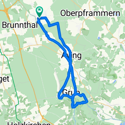
Höhenkirchen-Valley
A cycling route starting in Höhenkirchen-Siegertsbrunn, Bavaria, Germany.
Overview
About this route
Bahnhofsplatz, 85635 Höhenkirchen-Siegertsbrunn
Bräustüberl Valley
Tuesday to Sunday & public holidays from 11:00 am
- 4 h 24 min
- Duration
- 66 km
- Distance
- 841 m
- Ascent
- 842 m
- Descent
- 15 km/h
- Avg. speed
- 686 m
- Max. altitude

Route quality
Waytypes & surfaces along the route
Waytypes
Quiet road
30.4 km
(46 %)
Track
19.1 km
(29 %)
Surfaces
Paved
50.2 km
(76 %)
Unpaved
14.5 km
(22 %)
Asphalt
50.2 km
(76 %)
Gravel
13.9 km
(21 %)
Route highlights
Points of interest along the route
Point of interest after 46.4 km
Bräustüberl Valley Graf-Arco-Str. 28 83626 Valley
Continue with Bikemap
Use, edit, or download this cycling route
You would like to ride Höhenkirchen-Valley or customize it for your own trip? Here is what you can do with this Bikemap route:
Free features
- Save this route as favorite or in collections
- Copy & plan your own version of this route
- Sync your route with Garmin or Wahoo
Premium features
Free trial for 3 days, or one-time payment. More about Bikemap Premium.
- Navigate this route on iOS & Android
- Export a GPX / KML file of this route
- Create your custom printout (try it for free)
- Download this route for offline navigation
Discover more Premium features.
Get Bikemap PremiumFrom our community
Other popular routes starting in Höhenkirchen-Siegertsbrunn
 Weg zur Arbeit
- Distance
- 20.4 km
- Ascent
- 16 m
- Descent
- 90 m
- Location
- Höhenkirchen-Siegertsbrunn, Bavaria, Germany
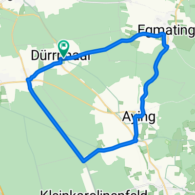
 2010-Tag2: Dürrnhaar-Bernau (Chiemsee)
- Distance
- 75.2 km
- Ascent
- 259 m
- Descent
- 336 m
- Location
- Höhenkirchen-Siegertsbrunn, Bavaria, Germany
 Höhenkirchen / Kleinhöhenkirchen mit Trails
- Distance
- 37.8 km
- Ascent
- 228 m
- Descent
- 228 m
- Location
- Höhenkirchen-Siegertsbrunn, Bavaria, Germany
 Aying-frauenbründel
- Distance
- 37.1 km
- Ascent
- 330 m
- Descent
- 330 m
- Location
- Höhenkirchen-Siegertsbrunn, Bavaria, Germany
 Rundfahrt Siegertsbrunn-Kirchstockach-Unterhaching-Neubiberg-Ottobrunn-Hohenbrunn-Siegertsbrunn
- Distance
- 26.3 km
- Ascent
- 22 m
- Descent
- 41 m
- Location
- Höhenkirchen-Siegertsbrunn, Bavaria, Germany
 Höhenkirchen-Valley
- Distance
- 66 km
- Ascent
- 841 m
- Descent
- 842 m
- Location
- Höhenkirchen-Siegertsbrunn, Bavaria, Germany
 31.1 Südroute
- Distance
- 31.7 km
- Ascent
- 108 m
- Descent
- 104 m
- Location
- Höhenkirchen-Siegertsbrunn, Bavaria, Germany
 Kleine Runde
- Distance
- 18.4 km
- Ascent
- 131 m
- Descent
- 129 m
- Location
- Höhenkirchen-Siegertsbrunn, Bavaria, Germany
Open it in the app