

Höllerersee - Runde
A cycling route starting in Dorfbeuern, Salzburg, Austria.
Overview
About this route
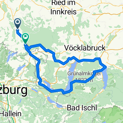
The route begins and ends as always in Dorfibm at the Zehentner farm. It leads southwest through Eisengö ring and crosses Holzöster street (L1010). It continues towards St. Pantaleon through the village of Steinwag. Shortly after Laubenbach, one turns off the highway to the right and follows the asphalt road west until the intersection with Höllerersee street. Here, one turns right heading north and follows the signs down to Höllerersee. There, one leaves Seeleiten road and turns left onto a forest path, following it to the north end of Höllerersees. Then it turns right up towards Pfaffing, in Pfaffing one turns right and travels to Frankinger state road (L504). Here, one turns right through the woods and then turns left north towards Hehermoos, from there proceeding to Holzöster. Here, one can shorten the route and continue directly west to the destination in Dorfibm or, if following the NAVI route, turn left north onto Holzöster street (L1010) until crossing Mühlen street (L1009) and continuing on a forest road through the woods to Werberg ('Jagdhaus'). From there, it continues down the big Frankinger road (L504) to Mühlberg and back to the starting point in Dorfibm.
- -:--
- Duration
- 20.8 km
- Distance
- 200 m
- Ascent
- 200 m
- Descent
- ---
- Avg. speed
- ---
- Max. altitude

Route quality
Waytypes & surfaces along the route
Waytypes
Quiet road
13.7 km
(66 %)
Road
3.7 km
(18 %)
Surfaces
Paved
0.8 km
(4 %)
Unpaved
1.2 km
(6 %)
Unpaved (undefined)
1.2 km
(6 %)
Asphalt
0.8 km
(4 %)
Undefined
18.7 km
(90 %)
Continue with Bikemap
Use, edit, or download this cycling route
You would like to ride Höllerersee - Runde or customize it for your own trip? Here is what you can do with this Bikemap route:
Free features
- Save this route as favorite or in collections
- Copy & plan your own version of this route
- Sync your route with Garmin or Wahoo
Premium features
Free trial for 3 days, or one-time payment. More about Bikemap Premium.
- Navigate this route on iOS & Android
- Export a GPX / KML file of this route
- Create your custom printout (try it for free)
- Download this route for offline navigation
Discover more Premium features.
Get Bikemap PremiumFrom our community
Other popular routes starting in Dorfbeuern
 Seenrundfahrt-Seelentium
- Distance
- 59.8 km
- Ascent
- 290 m
- Descent
- 290 m
- Location
- Dorfbeuern, Salzburg, Austria
 Mattighofen - Eggelsberg - Mattighofen
- Distance
- 48.6 km
- Ascent
- 514 m
- Descent
- 514 m
- Location
- Dorfbeuern, Salzburg, Austria
 Aufwärmrunde
- Distance
- 17.8 km
- Ascent
- 94 m
- Descent
- 93 m
- Location
- Dorfbeuern, Salzburg, Austria
 Mattighofen - Gaisberg - Mattighofen
- Distance
- 112.6 km
- Ascent
- 1,961 m
- Descent
- 1,931 m
- Location
- Dorfbeuern, Salzburg, Austria
 Mattighofen - Feldkirchen - Mattighofen
- Distance
- 41.3 km
- Ascent
- 462 m
- Descent
- 462 m
- Location
- Dorfbeuern, Salzburg, Austria
 Höllerersee - Runde
- Distance
- 20.8 km
- Ascent
- 200 m
- Descent
- 200 m
- Location
- Dorfbeuern, Salzburg, Austria
 2 Tage: Mattighofen - Gmunden - Mattighofen
- Distance
- 155.3 km
- Ascent
- 2,340 m
- Descent
- 2,248 m
- Location
- Dorfbeuern, Salzburg, Austria
 3 Berge - Kobernaußerwaldschleife
- Distance
- 99.9 km
- Ascent
- 1,000 m
- Descent
- 1,000 m
- Location
- Dorfbeuern, Salzburg, Austria
Open it in the app