

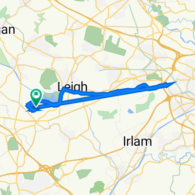
Upholland, Rainford and Billinge
A cycling route starting in Golborne, England, United Kingdom.
Overview
About this route
- -:--
- Duration
- 40.1 km
- Distance
- 249 m
- Ascent
- 250 m
- Descent
- ---
- Avg. speed
- ---
- Max. altitude

Route quality
Waytypes & surfaces along the route
Waytypes
Road
19.3 km
(48 %)
Quiet road
2.8 km
(7 %)
Surfaces
Paved
9.6 km
(24 %)
Unpaved
1.2 km
(3 %)
Asphalt
9.6 km
(24 %)
Unpaved (undefined)
1.2 km
(3 %)
Undefined
29.3 km
(73 %)
Continue with Bikemap
Use, edit, or download this cycling route
You would like to ride Upholland, Rainford and Billinge or customize it for your own trip? Here is what you can do with this Bikemap route:
Free features
- Save this route as favorite or in collections
- Copy & plan your own version of this route
- Sync your route with Garmin or Wahoo
Premium features
Free trial for 3 days, or one-time payment. More about Bikemap Premium.
- Navigate this route on iOS & Android
- Export a GPX / KML file of this route
- Create your custom printout (try it for free)
- Download this route for offline navigation
Discover more Premium features.
Get Bikemap PremiumFrom our community
Other popular routes starting in Golborne
 Lowton, Winwick and Culcheth
- Distance
- 21.7 km
- Ascent
- 63 m
- Descent
- 63 m
- Location
- Golborne, England, United Kingdom
 Southport
- Distance
- 98.6 km
- Ascent
- 302 m
- Descent
- 303 m
- Location
- Golborne, England, United Kingdom
 Lowton, Up Holland, Rainford and N-le-W
- Distance
- 48.9 km
- Ascent
- 226 m
- Descent
- 226 m
- Location
- Golborne, England, United Kingdom
 Appleton Thorn, High Legh and Warburton
- Distance
- 51.6 km
- Ascent
- 109 m
- Descent
- 108 m
- Location
- Golborne, England, United Kingdom
 Lowton to Southport
- Distance
- 100.7 km
- Ascent
- 302 m
- Descent
- 302 m
- Location
- Golborne, England, United Kingdom
 Raydale Close 7, Lowton to Ryecroft Avenue 19, Lowton
- Distance
- 30.2 km
- Ascent
- 187 m
- Descent
- 243 m
- Location
- Golborne, England, United Kingdom
 Upholland, Rainford and Billinge
- Distance
- 40.1 km
- Ascent
- 249 m
- Descent
- 250 m
- Location
- Golborne, England, United Kingdom
 Great Budworth, Ashley, Man Airport and Culcheth
- Distance
- 78.7 km
- Ascent
- 325 m
- Descent
- 325 m
- Location
- Golborne, England, United Kingdom
Open it in the app