

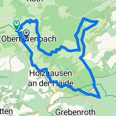
Heimatrunde
A cycling route starting in Obertiefenbach, Rhineland-Palatinate, Germany.
Overview
About this route
beautiful mid-mountain route in the Nassau region, wonderful views of Laurenburg, nice hairpins and great climbs up to 13/14%
- -:--
- Duration
- 40.6 km
- Distance
- 728 m
- Ascent
- 734 m
- Descent
- ---
- Avg. speed
- ---
- Max. altitude

Route quality
Waytypes & surfaces along the route
Waytypes
Road
14.6 km
(36 %)
Track
6.5 km
(16 %)
Surfaces
Paved
12.6 km
(31 %)
Unpaved
3.3 km
(8 %)
Asphalt
12.6 km
(31 %)
Ground
2 km
(5 %)
Continue with Bikemap
Use, edit, or download this cycling route
You would like to ride Heimatrunde or customize it for your own trip? Here is what you can do with this Bikemap route:
Free features
- Save this route as favorite or in collections
- Copy & plan your own version of this route
- Sync your route with Garmin or Wahoo
Premium features
Free trial for 3 days, or one-time payment. More about Bikemap Premium.
- Navigate this route on iOS & Android
- Export a GPX / KML file of this route
- Create your custom printout (try it for free)
- Download this route for offline navigation
Discover more Premium features.
Get Bikemap PremiumFrom our community
Other popular routes starting in Obertiefenbach
 Roth Mittelmühle
- Distance
- 16.8 km
- Ascent
- 378 m
- Descent
- 377 m
- Location
- Obertiefenbach, Rhineland-Palatinate, Germany
 Obertiefenbach US 34,7 530
- Distance
- 34.1 km
- Ascent
- 485 m
- Descent
- 485 m
- Location
- Obertiefenbach, Rhineland-Palatinate, Germany
 Heimatrunde
- Distance
- 40.6 km
- Ascent
- 728 m
- Descent
- 734 m
- Location
- Obertiefenbach, Rhineland-Palatinate, Germany
 OT - 39,7 - 600
- Distance
- 39.7 km
- Ascent
- 640 m
- Descent
- 639 m
- Location
- Obertiefenbach, Rhineland-Palatinate, Germany
 Römerkastell Rettert Niedertiefenbach
- Distance
- 26.6 km
- Ascent
- 554 m
- Descent
- 549 m
- Location
- Obertiefenbach, Rhineland-Palatinate, Germany
 Testrunde
- Distance
- 12.6 km
- Ascent
- 326 m
- Descent
- 326 m
- Location
- Obertiefenbach, Rhineland-Palatinate, Germany
 Tom Klee Geisig
- Distance
- 9.8 km
- Ascent
- 95 m
- Descent
- 223 m
- Location
- Obertiefenbach, Rhineland-Palatinate, Germany
 Dörsbachtal Runde
- Distance
- 42.3 km
- Ascent
- 601 m
- Descent
- 687 m
- Location
- Obertiefenbach, Rhineland-Palatinate, Germany
Open it in the app