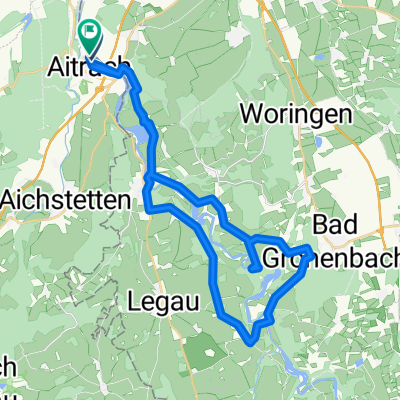
Sonntagsrunde ab Volkratshofen
A cycling route starting in Aitrach, Baden-Wurttemberg, Germany.
Overview
About this route
Nice route for a Sunday afternoon. Some climbs, but nothing extreme. Mostly small side roads, partly unpaved paths, but generally easy to ride. Lovely rest area at a pedal-powered installation near Lautrach. From here, the tour can also be shortened by 12 km by continuing directly to the bike path to Lautrach (old railway embankment).
- -:--
- Duration
- 51.2 km
- Distance
- 442 m
- Ascent
- 442 m
- Descent
- ---
- Avg. speed
- ---
- Max. altitude
Route quality
Waytypes & surfaces along the route
Waytypes
Quiet road
26.1 km
(51 %)
Road
13.3 km
(26 %)
Surfaces
Paved
16.9 km
(33 %)
Unpaved
6.1 km
(12 %)
Asphalt
12.3 km
(24 %)
Paved (undefined)
4.6 km
(9 %)
Route highlights
Points of interest along the route
Point of interest after 29.7 km
Schöner Rastplatz an einem Bach mit Tretanlage.
Continue with Bikemap
Use, edit, or download this cycling route
You would like to ride Sonntagsrunde ab Volkratshofen or customize it for your own trip? Here is what you can do with this Bikemap route:
Free features
- Save this route as favorite or in collections
- Copy & plan your own version of this route
- Sync your route with Garmin or Wahoo
Premium features
Free trial for 3 days, or one-time payment. More about Bikemap Premium.
- Navigate this route on iOS & Android
- Export a GPX / KML file of this route
- Create your custom printout (try it for free)
- Download this route for offline navigation
Discover more Premium features.
Get Bikemap PremiumFrom our community
Other popular routes starting in Aitrach
- Iller ab
- Distance
- 63.5 km
- Ascent
- 42 m
- Descent
- 142 m
- Location
- Aitrach, Baden-Wurttemberg, Germany
- Aitrach - Alcazar
- Distance
- 57.2 km
- Ascent
- 332 m
- Descent
- 332 m
- Location
- Aitrach, Baden-Wurttemberg, Germany
- Aitrach - Erolzheim - Aitrach
- Distance
- 61 km
- Ascent
- 390 m
- Descent
- 390 m
- Location
- Aitrach, Baden-Wurttemberg, Germany
- 33 "-hofen"-Tour
- Distance
- 81.6 km
- Ascent
- 431 m
- Descent
- 431 m
- Location
- Aitrach, Baden-Wurttemberg, Germany
- Illertal - Rothtal - Günztal - Runde
- Distance
- 90.8 km
- Ascent
- 232 m
- Descent
- 233 m
- Location
- Aitrach, Baden-Wurttemberg, Germany
- Rund um Memmingen
- Distance
- 64.5 km
- Ascent
- 316 m
- Descent
- 318 m
- Location
- Aitrach, Baden-Wurttemberg, Germany
- Kronburg - Feierabendrunde mit Biergarten
- Distance
- 24.2 km
- Ascent
- 204 m
- Descent
- 205 m
- Location
- Aitrach, Baden-Wurttemberg, Germany
- Hügelige Tour in den Illerwinkel und ins Rotistal
- Distance
- 44.2 km
- Ascent
- 380 m
- Descent
- 380 m
- Location
- Aitrach, Baden-Wurttemberg, Germany
Open it in the app