

Entre forêt et Seine depuis Canteleu (var)
A cycling route starting in Canteleu, Normandy, France.
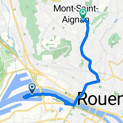
Overview
About this route
This is a variant of my eponymous route. This one allows you not to dismount at Val-De-La-Haye (difficult access). This variant does not go through the center of Canteleu or Saint-Martin-De-Bosherville (therefore, it is easier since at SMDB there is an 11% slope).
Along the way:
- Wildlife park,
- Gravel pond,
- Arboretum du Petit Charme (possibly the opportunity to go see the Epinay pond beforehand via a small path on the left)
- Then, a stony path that goes down well, be careful of sliding!
- Val-De-La-Haye: nice panorama (at sunrise)
- V33 up to Saint-Pierre-De-Manneville
- Then Quevillon, back through the forest (road then forest path)
- Passage via Route de Duclair (wide road but it goes fast)
The passage via Route de Sahurs allows you to avoid the GCUM on the V33 from Croisset (path on the sidewalk). But be careful with the timings when you take it, it goes fast!
Done on Gravel on 12/06/20.
- -:--
- Duration
- 36 km
- Distance
- 144 m
- Ascent
- 143 m
- Descent
- ---
- Avg. speed
- ---
- Max. altitude
Route photos
\"")
Route quality
Waytypes & surfaces along the route
Waytypes
Path
11.9 km
(33 %)
Road
8.3 km
(23 %)
Surfaces
Paved
20.9 km
(58 %)
Unpaved
2.9 km
(8 %)
Asphalt
19.8 km
(55 %)
Ground
2.2 km
(6 %)
Continue with Bikemap
Use, edit, or download this cycling route
You would like to ride Entre forêt et Seine depuis Canteleu (var) or customize it for your own trip? Here is what you can do with this Bikemap route:
Free features
- Save this route as favorite or in collections
- Copy & plan your own version of this route
- Sync your route with Garmin or Wahoo
Premium features
Free trial for 3 days, or one-time payment. More about Bikemap Premium.
- Navigate this route on iOS & Android
- Export a GPX / KML file of this route
- Create your custom printout (try it for free)
- Download this route for offline navigation
Discover more Premium features.
Get Bikemap PremiumFrom our community
Other popular routes starting in Canteleu
 Rouen - le Havre // mardi pour une expo
- Distance
- 81.3 km
- Ascent
- 202 m
- Descent
- 292 m
- Location
- Canteleu, Normandy, France
 Canteleu vers v33 par NDB, MSA
- Distance
- 55.9 km
- Ascent
- 312 m
- Descent
- 312 m
- Location
- Canteleu, Normandy, France
 Entre forêt et Seine depuis Canteleu (var)
- Distance
- 36 km
- Ascent
- 144 m
- Descent
- 143 m
- Location
- Canteleu, Normandy, France
 V33 depuis Canteleu
- Distance
- 32.4 km
- Ascent
- 176 m
- Descent
- 178 m
- Location
- Canteleu, Normandy, France
 Canteleu -- Le trait
- Distance
- 76.9 km
- Ascent
- 366 m
- Descent
- 366 m
- Location
- Canteleu, Normandy, France
 Au Nord de Canteleu
- Distance
- 38.1 km
- Ascent
- 291 m
- Descent
- 291 m
- Location
- Canteleu, Normandy, France
 Andelle - Crevon depuis Canteleu
- Distance
- 77.7 km
- Ascent
- 387 m
- Descent
- 387 m
- Location
- Canteleu, Normandy, France
 Easy ride in Rouen
- Distance
- 7.1 km
- Ascent
- 0 m
- Descent
- 6 m
- Location
- Canteleu, Normandy, France
Open it in the app