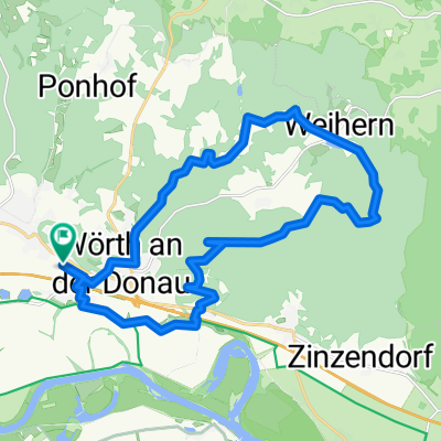
Gfäll - Falkenstein
A cycling route starting in Wörth an der Donau, Bavaria, Germany.
Overview
About this route
gefahren am 19.7.2020
- -:--
- Duration
- 37.9 km
- Distance
- 517 m
- Ascent
- 510 m
- Descent
- ---
- Avg. speed
- ---
- Avg. speed
Route quality
Waytypes & surfaces along the route
Waytypes
Quiet road
14.9 km
(39 %)
Track
12.5 km
(33 %)
Surfaces
Paved
5 km
(13 %)
Unpaved
16.1 km
(42 %)
Gravel
7.3 km
(19 %)
Loose gravel
6.1 km
(16 %)
Continue with Bikemap
Use, edit, or download this cycling route
You would like to ride Gfäll - Falkenstein or customize it for your own trip? Here is what you can do with this Bikemap route:
Free features
- Save this route as favorite or in collections
- Copy & plan your own version of this route
- Sync your route with Garmin or Wahoo
Premium features
Free trial for 3 days, or one-time payment. More about Bikemap Premium.
- Navigate this route on iOS & Android
- Export a GPX / KML file of this route
- Create your custom printout (try it for free)
- Download this route for offline navigation
Discover more Premium features.
Get Bikemap PremiumFrom our community
Other popular routes starting in Wörth an der Donau
- Mietnacht
- Distance
- 44.4 km
- Ascent
- 579 m
- Descent
- 588 m
- Location
- Wörth an der Donau, Bavaria, Germany
- 2010-Tag19: Wörthhof/Donau-Plattling
- Distance
- 63.8 km
- Ascent
- 76 m
- Descent
- 78 m
- Location
- Wörth an der Donau, Bavaria, Germany
- 2010 Wörth/Donau-Plattling
- Distance
- 57.8 km
- Ascent
- 82 m
- Descent
- 81 m
- Location
- Wörth an der Donau, Bavaria, Germany
- Brennberg Sulzbach 01
- Distance
- 39.2 km
- Ascent
- 492 m
- Descent
- 507 m
- Location
- Wörth an der Donau, Bavaria, Germany
- Wellerbach - Perlbach über Aumbach
- Distance
- 21.9 km
- Ascent
- 390 m
- Descent
- 391 m
- Location
- Wörth an der Donau, Bavaria, Germany
- D11 Wörth - Deggendorf
- Distance
- 67.9 km
- Ascent
- 81 m
- Descent
- 95 m
- Location
- Wörth an der Donau, Bavaria, Germany
- Perlbach Perlbach Paradies Wörth an der Donau
- Distance
- 29 km
- Ascent
- 443 m
- Descent
- 443 m
- Location
- Wörth an der Donau, Bavaria, Germany
- 2012 Wörth/Donau-Regensburg-Meihern/Altmühl
- Distance
- 97.5 km
- Ascent
- 107 m
- Descent
- 73 m
- Location
- Wörth an der Donau, Bavaria, Germany
Open it in the app