

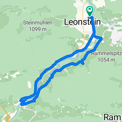
Schlierbach - Viechtwang
A cycling route starting in Micheldorf in Oberösterreich, Upper Austria, Austria.
Overview
About this route
Starting gently at the Schlierbach bus stop, the route leads over Inzersdorf on a longer climb to the highest point (633 SH) south of Magdalenaberg and offers a delightful descent down to Scharnsteiner-Strasse (498 SH). Afterwards slightly hilly to the Steinbach Bridge and the route runs near the Alm river up to the R11 (Almtalweg). On this to Viechtwang and through the village. After the village turn right up a climb to the church and the LGH Silmbrod (which are again on the R11).
The route runs mostly on low-traffic roads and offers wonderful views over the hills around Magdalenaberg and insights into the village landscapes and the Alm river with good visibility.
Tip: On Thursdays until 12:30 h there are steaming sausages to taste at GH Silmbrod.
- -:--
- Duration
- 17.9 km
- Distance
- 314 m
- Ascent
- 203 m
- Descent
- ---
- Avg. speed
- ---
- Max. altitude

Route quality
Waytypes & surfaces along the route
Waytypes
Quiet road
8.6 km
(48 %)
Road
4.3 km
(24 %)
Surfaces
Paved
6.1 km
(34 %)
Unpaved
0.4 km
(2 %)
Asphalt
5.9 km
(33 %)
Unpaved (undefined)
0.4 km
(2 %)
Continue with Bikemap
Use, edit, or download this cycling route
You would like to ride Schlierbach - Viechtwang or customize it for your own trip? Here is what you can do with this Bikemap route:
Free features
- Save this route as favorite or in collections
- Copy & plan your own version of this route
- Sync your route with Garmin or Wahoo
Premium features
Free trial for 3 days, or one-time payment. More about Bikemap Premium.
- Navigate this route on iOS & Android
- Export a GPX / KML file of this route
- Create your custom printout (try it for free)
- Download this route for offline navigation
Discover more Premium features.
Get Bikemap PremiumFrom our community
Other popular routes starting in Micheldorf in Oberösterreich
 Schlierbach - Viechtwang
- Distance
- 17.9 km
- Ascent
- 314 m
- Descent
- 203 m
- Location
- Micheldorf in Oberösterreich, Upper Austria, Austria
 Zimekrunde
- Distance
- 18.1 km
- Ascent
- 355 m
- Descent
- 356 m
- Location
- Micheldorf in Oberösterreich, Upper Austria, Austria
 Hochbaumgarten - Haindlmühle-Graben - Hochbaumgarten
- Distance
- 16.2 km
- Ascent
- 502 m
- Descent
- 493 m
- Location
- Micheldorf in Oberösterreich, Upper Austria, Austria
 2025_Micheldorf-Scharnstein
- Distance
- 54.6 km
- Ascent
- 2,176 m
- Descent
- 2,176 m
- Location
- Micheldorf in Oberösterreich, Upper Austria, Austria
 2025_04_29_Micheldorf- Hochberghaus-Micheldorf
- Distance
- 75.1 km
- Ascent
- 1,885 m
- Descent
- 1,886 m
- Location
- Micheldorf in Oberösterreich, Upper Austria, Austria
 2025_08_18_Micheldorf-Weyregg
- Distance
- 66.8 km
- Ascent
- 1,770 m
- Descent
- 1,754 m
- Location
- Micheldorf in Oberösterreich, Upper Austria, Austria
 zum See über Klaus am Radweg
- Distance
- 19.2 km
- Ascent
- 185 m
- Descent
- 177 m
- Location
- Micheldorf in Oberösterreich, Upper Austria, Austria
 RK Kremstalroas
- Distance
- 140.4 km
- Ascent
- 1,670 m
- Descent
- 1,670 m
- Location
- Micheldorf in Oberösterreich, Upper Austria, Austria
Open it in the app