

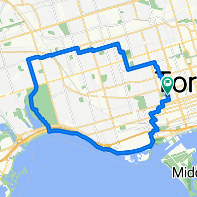
1 Waterfront Trail, Toronto to 2075 Queen St E, Toronto
A cycling route starting in Toronto, Ontario, Canada.
Overview
About this route
- 15 min
- Duration
- 4.3 km
- Distance
- 3 m
- Ascent
- 3 m
- Descent
- 17.5 km/h
- Avg. speed
- ---
- Max. altitude
Route quality
Waytypes & surfaces along the route
Waytypes
Cycleway
3.9 km
(90 %)
Access road
0.2 km
(5 %)
Surfaces
Paved
4.2 km
(96 %)
Asphalt
4.2 km
(96 %)
Undefined
0.2 km
(4 %)
Continue with Bikemap
Use, edit, or download this cycling route
You would like to ride 1 Waterfront Trail, Toronto to 2075 Queen St E, Toronto or customize it for your own trip? Here is what you can do with this Bikemap route:
Free features
- Save this route as favorite or in collections
- Copy & plan your own version of this route
- Sync your route with Garmin or Wahoo
Premium features
Free trial for 3 days, or one-time payment. More about Bikemap Premium.
- Navigate this route on iOS & Android
- Export a GPX / KML file of this route
- Create your custom printout (try it for free)
- Download this route for offline navigation
Discover more Premium features.
Get Bikemap PremiumFrom our community
Other popular routes starting in Toronto
 Lighthouse Loop, Toronto
- Distance
- 6.5 km
- Ascent
- 34 m
- Descent
- 4 m
- Location
- Toronto, Ontario, Canada
 East York to Indian Line campground
- Distance
- 47.4 km
- Ascent
- 242 m
- Descent
- 143 m
- Location
- Toronto, Ontario, Canada
 Cabana
- Distance
- 13.1 km
- Ascent
- 91 m
- Descent
- 93 m
- Location
- Toronto, Ontario, Canada
 Thicc bike bois
- Distance
- 61.3 km
- Ascent
- 173 m
- Descent
- 170 m
- Location
- Toronto, Ontario, Canada
 High Park
- Distance
- 18.4 km
- Ascent
- 63 m
- Descent
- 63 m
- Location
- Toronto, Ontario, Canada
 Gerrard Street East 257, Toronto to Waterfront Trail
- Distance
- 33.8 km
- Ascent
- 250 m
- Descent
- 265 m
- Location
- Toronto, Ontario, Canada
 - Short steep climbs & fast descents in the Beach
- Distance
- 5.4 km
- Ascent
- 107 m
- Descent
- 110 m
- Location
- Toronto, Ontario, Canada
 1 Waterfront Trail, Toronto to 2075 Queen St E, Toronto
- Distance
- 4.3 km
- Ascent
- 3 m
- Descent
- 3 m
- Location
- Toronto, Ontario, Canada
Open it in the app