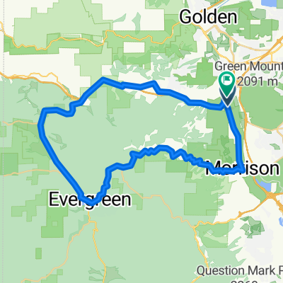
Denver Loop
A cycling route starting in West Pleasant View, Colorado, United States of America.
Overview
About this route
- -:--
- Duration
- 68.5 km
- Distance
- 387 m
- Ascent
- 380 m
- Descent
- ---
- Avg. speed
- ---
- Avg. speed
Route quality
Waytypes & surfaces along the route
Waytypes
Cycleway
39.6 km
(58 %)
Quiet road
12.1 km
(18 %)
Surfaces
Paved
61.7 km
(90 %)
Unpaved
0 km
(<1 %)
Concrete
24 km
(35 %)
Asphalt
21.3 km
(31 %)
Continue with Bikemap
Use, edit, or download this cycling route
You would like to ride Denver Loop or customize it for your own trip? Here is what you can do with this Bikemap route:
Free features
- Save this route as favorite or in collections
- Copy & plan your own version of this route
- Sync your route with Garmin or Wahoo
Premium features
Free trial for 3 days, or one-time payment. More about Bikemap Premium.
- Navigate this route on iOS & Android
- Export a GPX / KML file of this route
- Create your custom printout (try it for free)
- Download this route for offline navigation
Discover more Premium features.
Get Bikemap PremiumFrom our community
Other popular routes starting in West Pleasant View
- Nice loop
- Distance
- 86.2 km
- Ascent
- 1,305 m
- Descent
- 1,304 m
- Location
- West Pleasant View, Colorado, United States of America
- Violet Street 504, Golden to East Colfax Avenue 11220, Aurora
- Distance
- 35.9 km
- Ascent
- 383 m
- Descent
- 565 m
- Location
- West Pleasant View, Colorado, United States of America
- 02. Denver - Lincoln - Omaha
- Distance
- 1,046.8 km
- Ascent
- 2,163 m
- Descent
- 3,821 m
- Location
- West Pleasant View, Colorado, United States of America
- Denver Loop
- Distance
- 68.5 km
- Ascent
- 387 m
- Descent
- 380 m
- Location
- West Pleasant View, Colorado, United States of America
- Golden Short #2
- Distance
- 47.4 km
- Ascent
- 746 m
- Descent
- 748 m
- Location
- West Pleasant View, Colorado, United States of America
- Forgotten Ending
- Distance
- 6 km
- Ascent
- 174 m
- Descent
- 270 m
- Location
- West Pleasant View, Colorado, United States of America
- GM Short Ride #1
- Distance
- 12.6 km
- Ascent
- 533 m
- Descent
- 536 m
- Location
- West Pleasant View, Colorado, United States of America
- South Table Mesa
- Distance
- 11 km
- Ascent
- 212 m
- Descent
- 226 m
- Location
- West Pleasant View, Colorado, United States of America
Open it in the app