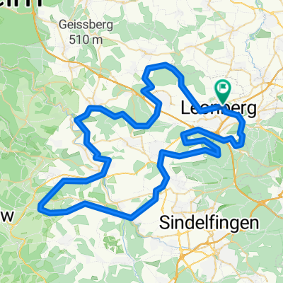
Über die Feinau
A cycling route starting in Leonberg, Baden-Württemberg, Germany.
Overview
About this route
Die ersten 10 km sind sehr bergig und steil. Der Rest dann eher flach
- -:--
- Duration
- 27.4 km
- Distance
- 326 m
- Ascent
- 326 m
- Descent
- ---
- Avg. speed
- ---
- Avg. speed
Route highlights
Points of interest along the route
Point of interest after 6.3 km
Biergarten
Point of interest after 16.6 km
Biergarten
Point of interest after 22.2 km
Naturfreundehaus "Wanne"
Continue with Bikemap
Use, edit, or download this cycling route
You would like to ride Über die Feinau or customize it for your own trip? Here is what you can do with this Bikemap route:
Free features
- Save this route as favorite or in collections
- Copy & plan your own version of this route
- Sync your route with Garmin or Wahoo
Premium features
Free trial for 3 days, or one-time payment. More about Bikemap Premium.
- Navigate this route on iOS & Android
- Export a GPX / KML file of this route
- Create your custom printout (try it for free)
- Download this route for offline navigation
Discover more Premium features.
Get Bikemap PremiumFrom our community
Other popular routes starting in Leonberg
- Leo - Sifi - Renningen - Leo
- Distance
- 30.7 km
- Ascent
- 404 m
- Descent
- 415 m
- Location
- Leonberg, Baden-Württemberg, Germany
- Rutesheim - Schillerhöhe
- Distance
- 27.2 km
- Ascent
- 304 m
- Descent
- 304 m
- Location
- Leonberg, Baden-Württemberg, Germany
- Enztal und Schwarzwald
- Distance
- 102.9 km
- Ascent
- 1,122 m
- Descent
- 1,122 m
- Location
- Leonberg, Baden-Württemberg, Germany
- Leonberg Tour de Natur 2008-Final
- Distance
- 35.6 km
- Ascent
- 335 m
- Descent
- 278 m
- Location
- Leonberg, Baden-Württemberg, Germany
- Sabine Leonberg
- Distance
- 49.3 km
- Ascent
- 480 m
- Descent
- 480 m
- Location
- Leonberg, Baden-Württemberg, Germany
- Rund um Leonberg
- Distance
- 39.6 km
- Ascent
- 415 m
- Descent
- 415 m
- Location
- Leonberg, Baden-Württemberg, Germany
- Meine ersten fast 50 Kilometer
- Distance
- 49.2 km
- Ascent
- 523 m
- Descent
- 486 m
- Location
- Leonberg, Baden-Württemberg, Germany
- Sabine Leonberg , grüner Heiner
- Distance
- 45 km
- Ascent
- 382 m
- Descent
- 383 m
- Location
- Leonberg, Baden-Württemberg, Germany
Open it in the app