

Budai Tajvedelmi Körzet
A cycling route starting in Budaörs, Pest County, Hungary.
Overview
About this route
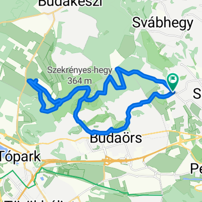
Nice route from Budapest Gazdagret through Budai Tajvedelmi Körzet towards Budakezi and back via Budaörs.
- -:--
- Duration
- 20.5 km
- Distance
- 543 m
- Ascent
- 544 m
- Descent
- ---
- Avg. speed
- ---
- Max. altitude
Continue with Bikemap
Use, edit, or download this cycling route
You would like to ride Budai Tajvedelmi Körzet or customize it for your own trip? Here is what you can do with this Bikemap route:
Free features
- Save this route as favorite or in collections
- Copy & plan your own version of this route
- Sync your route with Garmin or Wahoo
Premium features
Free trial for 3 days, or one-time payment. More about Bikemap Premium.
- Navigate this route on iOS & Android
- Export a GPX / KML file of this route
- Create your custom printout (try it for free)
- Download this route for offline navigation
Discover more Premium features.
Get Bikemap PremiumFrom our community
Other popular routes starting in Budaörs
 Susulyka u. to Velence
- Distance
- 59 km
- Ascent
- 482 m
- Descent
- 494 m
- Location
- Budaörs, Pest County, Hungary
 Unbenannte Route
- Distance
- 13.4 km
- Ascent
- 93 m
- Descent
- 48 m
- Location
- Budaörs, Pest County, Hungary
 Budai variáció
- Distance
- 29.1 km
- Ascent
- 858 m
- Descent
- 861 m
- Location
- Budaörs, Pest County, Hungary
 Hajtás (kis)Pajtás
- Distance
- 22.6 km
- Ascent
- 401 m
- Descent
- 400 m
- Location
- Budaörs, Pest County, Hungary
 Budai Tajvedelmi Körzet
- Distance
- 20.5 km
- Ascent
- 543 m
- Descent
- 544 m
- Location
- Budaörs, Pest County, Hungary
 KFKI - SZEPJUHASZNE (Budaorsi Csiki-hegyek kitero)
- Distance
- 19.7 km
- Ascent
- 388 m
- Descent
- 480 m
- Location
- Budaörs, Pest County, Hungary
 CBA - Velence
- Distance
- 58.1 km
- Ascent
- 545 m
- Descent
- 565 m
- Location
- Budaörs, Pest County, Hungary
 hajtás csere utáni teszt kör
- Distance
- 44.4 km
- Ascent
- 559 m
- Descent
- 541 m
- Location
- Budaörs, Pest County, Hungary
Open it in the app