

2020-06-11 18:03:29
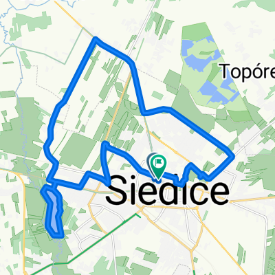
A cycling route starting in Siedlce, Masovian Voivodeship, Poland.
Overview
About this route
AktywnośćChodzenieOdległość3,6 kmUtworzono2020-06-11 18:03:29Maks. prędkość12,1 km/hTempo13:16 min/kmEnergia1417 KJPunkty265WszystkiePrędkość > 0Śr. prędkość4,5 km/h5,0 km/hCzas trasy0 h:47 min:48 sec0 h:43 min:09 secMin. wysokość114 mMaks. wysokość188 mPrzewyższenieOdległośćPod górę102 m1378 mZ góry-151 m1440 mPłasko0 m784 m
- -:--
- Duration
- 3.6 km
- Distance
- 8 m
- Ascent
- 39 m
- Descent
- ---
- Avg. speed
- ---
- Max. altitude

Continue with Bikemap
Use, edit, or download this cycling route
You would like to ride 2020-06-11 18:03:29 or customize it for your own trip? Here is what you can do with this Bikemap route:
Free features
- Save this route as favorite or in collections
- Copy & plan your own version of this route
- Sync your route with Garmin or Wahoo
Premium features
Free trial for 3 days, or one-time payment. More about Bikemap Premium.
- Navigate this route on iOS & Android
- Export a GPX / KML file of this route
- Create your custom printout (try it for free)
- Download this route for offline navigation
Discover more Premium features.
Get Bikemap PremiumFrom our community
Other popular routes starting in Siedlce
 2020-06-11 18:03:29
- Distance
- 3.6 km
- Ascent
- 8 m
- Descent
- 39 m
- Location
- Siedlce, Masovian Voivodeship, Poland
 Pierwsza udokumentowana
- Distance
- 20.6 km
- Ascent
- 38 m
- Descent
- 37 m
- Location
- Siedlce, Masovian Voivodeship, Poland
 pętla Siedlce/Krześlinek
- Distance
- 30.6 km
- Ascent
- 61 m
- Descent
- 61 m
- Location
- Siedlce, Masovian Voivodeship, Poland
 Siedlce Piaski/Strzała/ Iganie/Siedlce
- Distance
- 12.5 km
- Ascent
- 21 m
- Descent
- 22 m
- Location
- Siedlce, Masovian Voivodeship, Poland
 Siedlce-Mielnik
- Distance
- 98.5 km
- Ascent
- 230 m
- Descent
- 258 m
- Location
- Siedlce, Masovian Voivodeship, Poland
 20180714 Siedlce - Osieck v3
- Distance
- 86.8 km
- Ascent
- 136 m
- Descent
- 174 m
- Location
- Siedlce, Masovian Voivodeship, Poland
 Tour de Siedlce
- Distance
- 102.6 km
- Ascent
- 131 m
- Descent
- 133 m
- Location
- Siedlce, Masovian Voivodeship, Poland
 Siedlce - Skórzec - Olszyc - Stok Wiśniewski
- Distance
- 58.8 km
- Ascent
- 152 m
- Descent
- 154 m
- Location
- Siedlce, Masovian Voivodeship, Poland
Open it in the app