

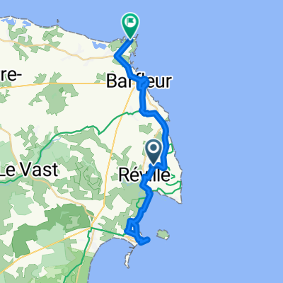
jour 3
A cycling route starting in Réville, Normandy, France.
Overview
About this route
jour 3
- -:--
- Duration
- 65.8 km
- Distance
- 36 m
- Ascent
- 41 m
- Descent
- ---
- Avg. speed
- ---
- Max. altitude

Route quality
Waytypes & surfaces along the route
Waytypes
Quiet road
25.7 km
(39 %)
Busy road
17.4 km
(26 %)
Surfaces
Paved
35.8 km
(54 %)
Unpaved
4.2 km
(6 %)
Asphalt
34.9 km
(53 %)
Gravel
2.2 km
(3 %)
Continue with Bikemap
Use, edit, or download this cycling route
You would like to ride jour 3 or customize it for your own trip? Here is what you can do with this Bikemap route:
Free features
- Save this route as favorite or in collections
- Copy & plan your own version of this route
- Sync your route with Garmin or Wahoo
Premium features
Free trial for 3 days, or one-time payment. More about Bikemap Premium.
- Navigate this route on iOS & Android
- Export a GPX / KML file of this route
- Create your custom printout (try it for free)
- Download this route for offline navigation
Discover more Premium features.
Get Bikemap PremiumFrom our community
Other popular routes starting in Réville
 20141025_CHATAIGNES
- Distance
- 36.6 km
- Ascent
- 459 m
- Descent
- 460 m
- Location
- Réville, Normandy, France
 jour 3
- Distance
- 65.8 km
- Ascent
- 36 m
- Descent
- 41 m
- Location
- Réville, Normandy, France
 20150710_103828.gpx
- Distance
- 43.9 km
- Ascent
- 38 m
- Descent
- 36 m
- Location
- Réville, Normandy, France
 Etape 5 :Barfleur Beaumont
- Distance
- 78 km
- Ascent
- 551 m
- Descent
- 395 m
- Location
- Réville, Normandy, France
 Anneville to lighthouse
- Distance
- 19 km
- Ascent
- 42 m
- Descent
- 42 m
- Location
- Réville, Normandy, France
 barfleur - la pernelle- saint martin de bonfossé
- Distance
- 98.1 km
- Ascent
- 415 m
- Descent
- 311 m
- Location
- Réville, Normandy, France
 7 Chemin des Petites Cachettes, Réville à 14 Résidence du Vieux Colombier, Saint-Vaast-la-Hougue
- Distance
- 4.8 km
- Ascent
- 17 m
- Descent
- 22 m
- Location
- Réville, Normandy, France
 De Route des Monts à Route du Phare 5152A
- Distance
- 28.4 km
- Ascent
- 55 m
- Descent
- 108 m
- Location
- Réville, Normandy, France
Open it in the app