

Pour se faire les mollets au Nord-Ouest de Rouen (var)
A cycling route starting in Roumare, Normandy, France.
Overview
About this route
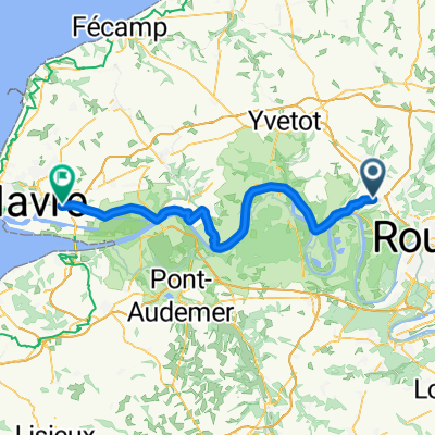
Loop starting from Roumare, towards Duclair: green avenue from Duclair to Saint-Vandrille (the flattest part of the route).
The rest is a succession of climbs and descents more or less steep.
Some sections a bit more dangerous (due to motorists driving like maniacs), but overall a nice ride with clear views, spots in the forest...
For the green avenue, the part after Le Trait was not yet inaugurated when I did the route (20/06/20) but it was possible to pass.
The cavée des Monts in Duclair is one-way except for residents; it would deserve a 'except cyclists' to avoid a more dangerous road.
On the road to Barentin, there is the possibility to take a path that seems to be pedestrian but leads nowhere. This allows for a peaceful ascent away from motorized vehicles but in the wrong direction).
Variant of the loop of the same name without going through the small railway path (very stony at the beginning).
https://www.bikemap.net/en/r/6405421/#14.79/49.51069/0.96728
- -:--
- Duration
- 73.6 km
- Distance
- 828 m
- Ascent
- 829 m
- Descent
- ---
- Avg. speed
- ---
- Max. altitude
Route photos
\"")
Route quality
Waytypes & surfaces along the route
Waytypes
Road
33.9 km
(46 %)
Path
16.2 km
(22 %)
Surfaces
Paved
48.6 km
(66 %)
Unpaved
4.4 km
(6 %)
Asphalt
48.6 km
(66 %)
Ground
3.7 km
(5 %)
Continue with Bikemap
Use, edit, or download this cycling route
You would like to ride Pour se faire les mollets au Nord-Ouest de Rouen (var) or customize it for your own trip? Here is what you can do with this Bikemap route:
Free features
- Save this route as favorite or in collections
- Copy & plan your own version of this route
- Sync your route with Garmin or Wahoo
Premium features
Free trial for 3 days, or one-time payment. More about Bikemap Premium.
- Navigate this route on iOS & Android
- Export a GPX / KML file of this route
- Create your custom printout (try it for free)
- Download this route for offline navigation
Discover more Premium features.
Get Bikemap PremiumFrom our community
Other popular routes starting in Roumare
 Roumare - Rogerville
- Distance
- 75.5 km
- Ascent
- 227 m
- Descent
- 344 m
- Location
- Roumare, Normandy, France
 Cyclotourisme à l'ouest de Canteleu
- Distance
- 75.3 km
- Ascent
- 860 m
- Descent
- 861 m
- Location
- Roumare, Normandy, France
 Pour se faire les mollets au Nord-Ouest de Rouen
- Distance
- 74 km
- Ascent
- 815 m
- Descent
- 816 m
- Location
- Roumare, Normandy, France
 2DIves-sur-mer
- Distance
- 104.7 km
- Ascent
- 536 m
- Descent
- 645 m
- Location
- Roumare, Normandy, France
 A la campagne autour de Roumare
- Distance
- 35.4 km
- Ascent
- 365 m
- Descent
- 363 m
- Location
- Roumare, Normandy, France
 Route des Deux Tilleuls, Roumare à Chemin du Marais, Duclair
- Distance
- 11 km
- Ascent
- 67 m
- Descent
- 197 m
- Location
- Roumare, Normandy, France
 Pour se faire les mollets au Nord-Ouest de Rouen (var)
- Distance
- 73.6 km
- Ascent
- 828 m
- Descent
- 829 m
- Location
- Roumare, Normandy, France
Open it in the app