

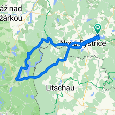
Nová Bystřice-Landštejn
A cycling route starting in Nová Bystřice, Jihočeský kraj, Czechia.
Overview
About this route
The more information you write here, the more useful it will be for other users.* Route progression.* What is special about this route?* Why recommend this route?* What did you like most here?* Etc.
- -:--
- Duration
- 32.9 km
- Distance
- 404 m
- Ascent
- 404 m
- Descent
- ---
- Avg. speed
- ---
- Max. altitude
Route quality
Waytypes & surfaces along the route
Waytypes
Road
14.5 km
(44 %)
Track
12.2 km
(37 %)
Surfaces
Paved
9.9 km
(30 %)
Unpaved
4.9 km
(15 %)
Asphalt
9.5 km
(29 %)
Ground
2 km
(6 %)
Route highlights
Points of interest along the route
Point of interest after 4.8 km
Point of interest after 6.3 km
Continue with Bikemap
Use, edit, or download this cycling route
You would like to ride Nová Bystřice-Landštejn or customize it for your own trip? Here is what you can do with this Bikemap route:
Free features
- Save this route as favorite or in collections
- Copy & plan your own version of this route
- Sync your route with Garmin or Wahoo
Premium features
Free trial for 3 days, or one-time payment. More about Bikemap Premium.
- Navigate this route on iOS & Android
- Export a GPX / KML file of this route
- Create your custom printout (try it for free)
- Download this route for offline navigation
Discover more Premium features.
Get Bikemap PremiumFrom our community
Other popular routes starting in Nová Bystřice
 Czeska Kanada 3
- Distance
- 50.6 km
- Ascent
- 562 m
- Descent
- 562 m
- Location
- Nová Bystřice, Jihočeský kraj, Czechia
 Nová Bystřice-Landštejn
- Distance
- 32.9 km
- Ascent
- 404 m
- Descent
- 404 m
- Location
- Nová Bystřice, Jihočeský kraj, Czechia
 Nová Bystřice - Hirschenschlag - Haugschlag - Chlum - Stráž nad Nežárkou - Peršlág - Nová Bystřice
- Distance
- 63.2 km
- Ascent
- 374 m
- Descent
- 374 m
- Location
- Nová Bystřice, Jihočeský kraj, Czechia
 Českou Kanadou - dlouhá
- Distance
- 49.8 km
- Ascent
- 660 m
- Descent
- 626 m
- Location
- Nová Bystřice, Jihočeský kraj, Czechia
 Nová Bystřice - Chlum u Třeboně
- Distance
- 46 km
- Ascent
- 399 m
- Descent
- 434 m
- Location
- Nová Bystřice, Jihočeský kraj, Czechia
 Nová Bystřice - Český Rudolec - Kunžak - Nová Bystřice
- Distance
- 49.8 km
- Ascent
- 540 m
- Descent
- 540 m
- Location
- Nová Bystřice, Jihočeský kraj, Czechia
 N. Bystřice - Staňkov (TR43 v1.2.1)
- Distance
- 46.4 km
- Ascent
- 445 m
- Descent
- 445 m
- Location
- Nová Bystřice, Jihočeský kraj, Czechia
 Krakau Heimweg 5
- Distance
- 145 km
- Ascent
- 6,890 m
- Descent
- 6,897 m
- Location
- Nová Bystřice, Jihočeský kraj, Czechia
Open it in the app