

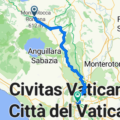
ViaFrancigena-Tp6-Sutri-Piazza San Pietro (Roma)
A cycling route starting in Sutri, Lazio, Italy.
Overview
About this route
- -:--
- Duration
- 64.5 km
- Distance
- 891 m
- Ascent
- 1,170 m
- Descent
- ---
- Avg. speed
- ---
- Max. altitude

Continue with Bikemap
Use, edit, or download this cycling route
You would like to ride ViaFrancigena-Tp6-Sutri-Piazza San Pietro (Roma) or customize it for your own trip? Here is what you can do with this Bikemap route:
Free features
- Save this route as favorite or in collections
- Copy & plan your own version of this route
- Sync your route with Garmin or Wahoo
Premium features
Free trial for 3 days, or one-time payment. More about Bikemap Premium.
- Navigate this route on iOS & Android
- Export a GPX / KML file of this route
- Create your custom printout (try it for free)
- Download this route for offline navigation
Discover more Premium features.
Get Bikemap PremiumFrom our community
Other popular routes starting in Sutri
 Da Via Reginaldo Caffarelli a Via dei Condotti
- Distance
- 63.5 km
- Ascent
- 731 m
- Descent
- 780 m
- Location
- Sutri, Lazio, Italy
 VF 15 Sutri - Roma
- Distance
- 67.9 km
- Ascent
- 352 m
- Descent
- 595 m
- Location
- Sutri, Lazio, Italy
 05-Sutri_Roma
- Distance
- 81.9 km
- Ascent
- 342 m
- Descent
- 628 m
- Location
- Sutri, Lazio, Italy
 ViaFrancigena-Tp6-Sutri-Piazza San Pietro (Roma)
- Distance
- 64.5 km
- Ascent
- 891 m
- Descent
- 1,170 m
- Location
- Sutri, Lazio, Italy
 Sutri - Campagnano
- Distance
- 23.4 km
- Ascent
- 245 m
- Descent
- 242 m
- Location
- Sutri, Lazio, Italy
 WTVF-B4-3-BorgoDiSutri-Campagnano-2023
- Distance
- 24.5 km
- Ascent
- 325 m
- Descent
- 325 m
- Location
- Sutri, Lazio, Italy
 Frankerstien6
- Distance
- 73.6 km
- Ascent
- 477 m
- Descent
- 663 m
- Location
- Sutri, Lazio, Italy
 Sutri,M.Calvi (s.t),Poggio Stracciacappello
- Distance
- 28.9 km
- Ascent
- 832 m
- Descent
- 828 m
- Location
- Sutri, Lazio, Italy
Open it in the app