

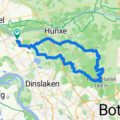
Keer Tröch
A cycling route starting in Voerde, North Rhine-Westphalia, Germany.
Overview
About this route
- -:--
- Duration
- 35.5 km
- Distance
- 55 m
- Ascent
- 55 m
- Descent
- ---
- Avg. speed
- ---
- Max. altitude

Route quality
Waytypes & surfaces along the route
Waytypes
Path
12.1 km
(34 %)
Quiet road
9.2 km
(26 %)
Surfaces
Paved
23 km
(65 %)
Unpaved
3.9 km
(11 %)
Asphalt
16.9 km
(48 %)
Paving stones
6 km
(17 %)
Continue with Bikemap
Use, edit, or download this cycling route
You would like to ride Keer Tröch or customize it for your own trip? Here is what you can do with this Bikemap route:
Free features
- Save this route as favorite or in collections
- Copy & plan your own version of this route
- Sync your route with Garmin or Wahoo
Premium features
Free trial for 3 days, or one-time payment. More about Bikemap Premium.
- Navigate this route on iOS & Android
- Export a GPX / KML file of this route
- Create your custom printout (try it for free)
- Download this route for offline navigation
Discover more Premium features.
Get Bikemap PremiumFrom our community
Other popular routes starting in Voerde
 Keer Tröch
- Distance
- 35.5 km
- Ascent
- 55 m
- Descent
- 55 m
- Location
- Voerde, North Rhine-Westphalia, Germany
 Feierabendrunde entlang des Rheins über Wesel anschließend Lippefähre
- Distance
- 29.2 km
- Ascent
- 3 m
- Descent
- 24 m
- Location
- Voerde, North Rhine-Westphalia, Germany
 Marberts Grafenmühle-Tour 11.7.2010
- Distance
- 45.5 km
- Ascent
- 140 m
- Descent
- 140 m
- Location
- Voerde, North Rhine-Westphalia, Germany
 NR204: Rotbach, Rhein und Kanal
- Distance
- 40.3 km
- Ascent
- 175 m
- Descent
- 175 m
- Location
- Voerde, North Rhine-Westphalia, Germany
 Grüne Halde
- Distance
- 32.2 km
- Ascent
- 168 m
- Descent
- 169 m
- Location
- Voerde, North Rhine-Westphalia, Germany
 Standardrunde ca. 30km
- Distance
- 29.2 km
- Ascent
- 65 m
- Descent
- 68 m
- Location
- Voerde, North Rhine-Westphalia, Germany
 Mühlenbach - Tester Berge
- Distance
- 28.6 km
- Ascent
- 94 m
- Descent
- 96 m
- Location
- Voerde, North Rhine-Westphalia, Germany
 Kronprinzenstraße 37, Voerde (Niederrhein) nach Kronprinzenstraße 15, Voerde (Niederrhein)
- Distance
- 49 km
- Ascent
- 232 m
- Descent
- 235 m
- Location
- Voerde, North Rhine-Westphalia, Germany
Open it in the app