
202006 Loire Cycle with Eva
A cycling route starting in Saint-Pierre-des-Corps, Centre-Val de Loire, France.
Overview
About this route
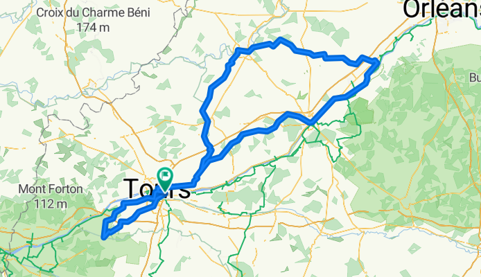
Tours Blois Tavers Vendome Azay le Rideau Tours
- -:--
- Duration
- 279 km
- Distance
- 339 m
- Ascent
- 341 m
- Descent
- ---
- Avg. speed
- ---
- Max. altitude

Route quality
Waytypes & surfaces along the route
Waytypes
Quiet road
111.6 km
(40 %)
Road
86.5 km
(31 %)
Surfaces
Paved
125.6 km
(45 %)
Unpaved
5.6 km
(2 %)
Asphalt
120 km
(43 %)
Paved (undefined)
2.8 km
(1 %)
Continue with Bikemap
Use, edit, or download this cycling route
You would like to ride 202006 Loire Cycle with Eva or customize it for your own trip? Here is what you can do with this Bikemap route:
Free features
- Save this route as favorite or in collections
- Copy & plan your own version of this route
- Split it into stages to create a multi-day tour
- Sync your route with Garmin or Wahoo
Premium features
Free trial for 3 days, or one-time payment. More about Bikemap Premium.
- Navigate this route on iOS & Android
- Export a GPX / KML file of this route
- Create your custom printout (try it for free)
- Download this route for offline navigation
Discover more Premium features.
Get Bikemap PremiumFrom our community
Other popular routes starting in Saint-Pierre-des-Corps
 Travail / Domicile
- Distance
- 7.6 km
- Ascent
- 54 m
- Descent
- 23 m
- Location
- Saint-Pierre-des-Corps, Centre-Val de Loire, France
 Saint pierre des corps - angers
- Distance
- 129.6 km
- Ascent
- 218 m
- Descent
- 248 m
- Location
- Saint-Pierre-des-Corps, Centre-Val de Loire, France
 WESTERN LOOP FROM TOURS
- Distance
- 69.6 km
- Ascent
- 142 m
- Descent
- 142 m
- Location
- Saint-Pierre-des-Corps, Centre-Val de Loire, France
 Tours - Pitiers
- Distance
- 99.5 km
- Ascent
- 336 m
- Descent
- 262 m
- Location
- Saint-Pierre-des-Corps, Centre-Val de Loire, France
 Saint-Pierre-des-Corps - Avoine
- Distance
- 55.3 km
- Ascent
- 145 m
- Descent
- 161 m
- Location
- Saint-Pierre-des-Corps, Centre-Val de Loire, France
 Tours Chatellerault
- Distance
- 87.6 km
- Ascent
- 323 m
- Descent
- 321 m
- Location
- Saint-Pierre-des-Corps, Centre-Val de Loire, France
 1992 - Atlantik - Mosel - 4. Tag - Saint-Pierre-des-Corps - Saint-Jean-de-Braye
- Distance
- 119.8 km
- Ascent
- 358 m
- Descent
- 310 m
- Location
- Saint-Pierre-des-Corps, Centre-Val de Loire, France
 1 bis St Pierre Saumur
- Distance
- 74.3 km
- Ascent
- 90 m
- Descent
- 91 m
- Location
- Saint-Pierre-des-Corps, Centre-Val de Loire, France
Open it in the app