

Durch das schöne Ruhrtal MH-Essen
A cycling route starting in Mülheim, North Rhine-Westphalia, Germany.
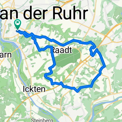
Overview
About this route
- -:--
- Duration
- 46.7 km
- Distance
- 187 m
- Ascent
- 192 m
- Descent
- ---
- Avg. speed
- ---
- Max. altitude

Route quality
Waytypes & surfaces along the route
Waytypes
Path
19.6 km
(42 %)
Cycleway
10.3 km
(22 %)
Surfaces
Paved
35.5 km
(76 %)
Unpaved
7.9 km
(17 %)
Asphalt
34.6 km
(74 %)
Gravel
7.9 km
(17 %)
Continue with Bikemap
Use, edit, or download this cycling route
You would like to ride Durch das schöne Ruhrtal MH-Essen or customize it for your own trip? Here is what you can do with this Bikemap route:
Free features
- Save this route as favorite or in collections
- Copy & plan your own version of this route
- Sync your route with Garmin or Wahoo
Premium features
Free trial for 3 days, or one-time payment. More about Bikemap Premium.
- Navigate this route on iOS & Android
- Export a GPX / KML file of this route
- Create your custom printout (try it for free)
- Download this route for offline navigation
Discover more Premium features.
Get Bikemap PremiumFrom our community
Other popular routes starting in Mülheim
 berg und Tal
- Distance
- 46.5 km
- Ascent
- 949 m
- Descent
- 1,004 m
- Location
- Mülheim, North Rhine-Westphalia, Germany
 Rund um den Flughafen
- Distance
- 19.9 km
- Ascent
- 204 m
- Descent
- 204 m
- Location
- Mülheim, North Rhine-Westphalia, Germany
 Mülheim - Ruhrtal - Essen - Mülheim (510 HM) CLONED FROM ROUTE 36149
- Distance
- 44 km
- Ascent
- 238 m
- Descent
- 238 m
- Location
- Mülheim, North Rhine-Westphalia, Germany
 Mülheim - Krefeld - Meerbusch -Düsseldorf
- Distance
- 77.7 km
- Ascent
- 144 m
- Descent
- 167 m
- Location
- Mülheim, North Rhine-Westphalia, Germany
 Zur Ruhrmündung
- Distance
- 32.6 km
- Ascent
- 51 m
- Descent
- 53 m
- Location
- Mülheim, North Rhine-Westphalia, Germany
 mülheim-Baldeneysee-Mülheim
- Distance
- 48.6 km
- Ascent
- 130 m
- Descent
- 128 m
- Location
- Mülheim, North Rhine-Westphalia, Germany
 Über stillgelegte Bahnstrecken
- Distance
- 58.1 km
- Ascent
- 91 m
- Descent
- 91 m
- Location
- Mülheim, North Rhine-Westphalia, Germany
 Saarn-Selbeck-Breitscheid-Saarn
- Distance
- 19 km
- Ascent
- 91 m
- Descent
- 89 m
- Location
- Mülheim, North Rhine-Westphalia, Germany
Open it in the app